File:Falklandsmap.gif
Jump to navigation
Jump to search
No higher resolution available.
Falklandsmap.gif (350 × 376 pixels, file size: 12 KB, MIME type: image/gif)
| This is a file from the Wikimedia Commons. Information from its description page there is shown below. Commons is a freely licensed media file repository. You can help. |
Summary
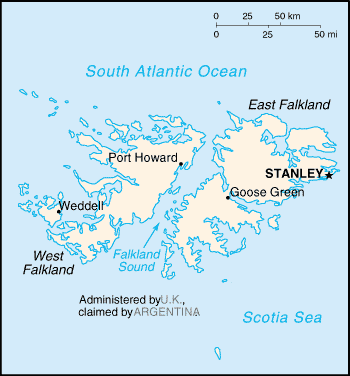
| Description |
English: A map of the Falkland Islands (Islas Malvinas), showing island names and major towns. |
|||
| Date | published 2004 | |||
| Source | CIA, The World Factbook, 2004. | |||
| Author | CIA | |||
| Permission (Reusing this file) |
|

- first upload: March 27, 2004 - en:Wikipedia
| Camera location | | View this and other nearby images on: OpenStreetMap |
|---|
derivative works
Derivative works of this file: Weddell Island.PNG
File history
Click on a date/time to view the file as it appeared at that time.
| Date/Time | Thumbnail | Dimensions | User | Comment | |
|---|---|---|---|---|---|
| current | 16:11, 25 February 2005 | | 350 × 376 (12 KB) | Nordelch | {{PD}} |
File usage
There are no pages that use this file.
Global file usage
The following other wikis use this file:
- Usage on azb.wikipedia.org
- Usage on be-tarask.wikipedia.org
- Usage on bs.wikipedia.org
- Usage on ca.wikipedia.org
- Usage on de.wikibooks.org
- Usage on en.wikibooks.org
- Usage on fi.wikipedia.org
- Usage on fr.wikipedia.org
- Usage on gl.wikipedia.org
- Usage on hr.wikipedia.org
- Usage on hr.wiktionary.org
- Usage on it.wikibooks.org
- Usage on ja.wikipedia.org
- Usage on lo.wikipedia.org
- Usage on mr.wikipedia.org
- Usage on no.wikipedia.org
- Usage on se.wikipedia.org
- Usage on th.wikipedia.org
- Usage on tr.wikipedia.org