File:Oregon map Colliers.png
Jump to navigation
Jump to search

Size of this preview: 737 × 600 pixels. Other resolutions: 295 × 240 pixels | 590 × 480 pixels | 944 × 768 pixels | 1,258 × 1,024 pixels | 2,280 × 1,856 pixels.
Original file (2,280 × 1,856 pixels, file size: 10.7 MB, MIME type: image/png)
| This is a file from the Wikimedia Commons. Information from its description page there is shown below. Commons is a freely licensed media file repository. You can help. |
Summary
| Description |
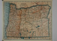
English: Map of Oregon from Collier's New Encyclopedia (1921). |
| Date | |
| Source | Collier's New Encyclopedia, v. 7, 1921, facing p. 41. |
| Author | Collier's New Encyclopledia |
| Other versions |
 |
Licensing
This media file is in the public domain in the United States. This applies to U.S. works where the copyright has expired, often because its first publication occurred prior to January 1, 1929, and if not then due to lack of notice or renewal. See this page for further explanation.
|
 | |
 |
File history
Click on a date/time to view the file as it appeared at that time.
| Date/Time | Thumbnail | Dimensions | User | Comment | |
|---|---|---|---|---|---|
| current | 20:08, 25 April 2018 | | 2,280 × 1,856 (10.7 MB) | Bob Burkhardt | crop more closely; remove some splotches and Poates attribution |
| 20:47, 5 April 2018 |  | 2,280 × 1,872 (7.12 MB) | Peteforsyth | adjust color & cropping on full-res version | |
| 20:43, 5 April 2018 |  | 2,700 × 1,973 (6.61 MB) | Peteforsyth | Higher resolution thanks to Hesperian bot (missed this before) | |
| 20:40, 5 April 2018 |  | 2,276 × 1,873 (2.65 MB) | Peteforsyth | adjust colors (and recrop a little tighter) | |
| 06:34, 25 October 2010 |  | 2,298 × 1,886 (3.22 MB) | Peteforsyth | crop | |
| 06:31, 25 October 2010 |  | 2,700 × 1,973 (2.86 MB) | Peteforsyth | {{Information |Description={{en|1=Map of Oregon from Collier's New Encyclopedia (1921).}} |Source=http://www.archive.org/details/colliersnewencyc07newy |Author=Collier's New Encyclopledia |Date=1921 |Permission= |other_versions=Oregon.tif }} [[Category:M |
File usage
The following 2 pages use this file: