semitones. These instruments resemble the saxophones (q.v.), having the bell joint bent up in front and the crook almost at right angles backwards, but the bore of the saxophone is conical.
Georg Streitwolf (1779–1837), an ingenious musical instrument-maker of Göttingen, produced in 1828 a bass clarinet with a compass extending from A♭ to F, nineteen keys and a fingering the same as that of the clarinet with but few exceptions. In form it resembled the fagotto and had a crook terminating in a beak mouthpiece. The Streitwolf bass clarinet was adopted in 1834 by the Prussian infantry as bass to the wood-wind.[1] Streitwolf’s first bass clarinets were in C, but later he constructed instruments in B♭ as well. Like the basset horn, Streitwolf’s instruments had the four chromatic open keys extending the compass downwards to B♭. The tone was of very fine quality. One of these instruments is in the possession of Herr C. Kruspe of Erfurt,[2] and another is preserved in the Berlin collection at the Hochschule.
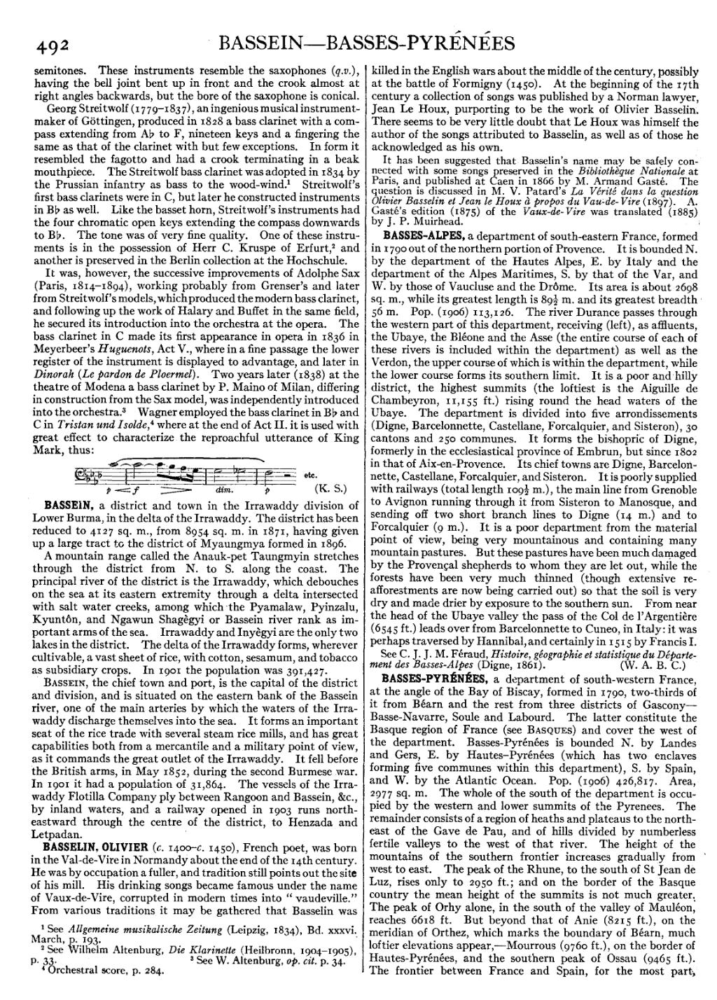
It was, however, the successive improvements of Adolphe Sax (Paris, 1814–1894), working probably from Grenser’s and later from Streitwolf’s models, which produced the modern bass clarinet, and following up the work of Halary and Buffet in the same field, he secured its introduction into the orchestra at the opera. The bass clarinet in C made its first appearance in opera in 1836 in Meyerbeer’s Huguenots, Act V., where in a fine passage the lower register of the instrument is displayed to advantage, and later in Dinorah (Le pardon de Ploermel). Two years later (1838) at the theatre of Modena a bass clarinet by P. Maino of Milan, differing in construction from the Sax model, was independently introduced into the orchestra.[3] Wagner employed the bass clarinet in B♭ and C in Tristan und Isolde,[4] where at the end of Act II. it is used with great effect to characterize the reproachful utterance of King Mark, thus:

(K. S.)
BASSEIN, a district and town in the Irrawaddy division of Lower Burma, in the delta of the Irrawaddy. The district has been reduced to 4127 sq. m., from 8954 sq. m. in 1871, having given up a large tract to the district of Myaungmya formed in 1896.
A mountain range called the Anauk-pet Taungmyin stretches through the district from N. to S. along the coast. The principal river of the district is the Irrawaddy, which debouches on the sea at its eastern extremity through a delta intersected with salt water creeks, among which the Pyamalaw, Pyinzalu, Kyuntôn, and Ngawun Shagègyi or Bassein river rank as important arms of the sea. Irrawaddy and Inyègyi are the only two lakes in the district. The delta of the Irrawaddy forms, wherever cultivable, a vast sheet of rice, with cotton, sesamum, and tobacco as subsidiary crops. In 1901 the population was 391,427.
Bassein, the chief town and port, is the capital of the district and division, and is situated on the eastern bank of the Bassein river, one of the main arteries by which the waters of the Irrawaddy discharge themselves into the sea. It forms an important seat of the rice trade with several steam rice mills, and has great capabilities both from a mercantile and a military point of view, as it commands the great outlet of the Irrawaddy. It fell before the British arms, in May 1852, during the second Burmese war. In 1901 it had a population of 31,864. The vessels of the Irrawaddy Flotilla Company ply between Rangoon and Bassein, &c., by inland waters, and a railway opened in 1903 runs north-eastward through the centre of the district, to Henzada and Letpadan.
BASSELIN, OLIVIER (c. 1400–c. 1450), French poet, was born in the Val-de-Vire in Normandy about the end of the 14th century. He was by occupation a fuller, and tradition still points out the site of his mill. His drinking songs became famous under the name of Vaux-de-Vire, corrupted in modern times into “vaudeville.” From various traditions it may be gathered that Basselin was killed in the English wars about the middle of the century, possibly at the battle of Formigny (1450). At the beginning of the 17th century a collection of songs was published by a Norman lawyer, Jean Le Houx, purporting to be the work of Olivier Basselin. There seems to be very little doubt that Le Houx was himself the author of the songs attributed to Basselin, as well as of those he acknowledged as his own.
It has been suggested that Basselin’s name may be safely connected with some songs preserved in the Bibliothèque Nationale at Paris, and published at Caen in 1866 by M. Armand Gasté. The question is discussed in M. V. Patard’s La Vérité dans la question Olivier Basselin et Jean le Houx à propos du Vau-de-Vire (1897). A. Gasté’s edition (1875) of the Vaux-de-Vire was translated (1885) by J. P. Muirhead.
BASSES-ALPES, a department of south-eastern France, formed in 1790 out of the northern portion of Provence. It is bounded N. by the department of the Hautes Alpes, E. by Italy and the department of the Alpes Maritimes, S. by that of the Var, and W. by those of Vaucluse and the Drôme. Its area is about 2698 sq. m., while its greatest length is 8912 m. and its greatest breadth 56 m. Pop. (1906) 113,126. The river Durance passes through the western part of this department, receiving (left), as affluents, the Ubaye, the Bléone and the Asse (the entire course of each of these rivers is included within the department) as well as the Verdon, the upper course of which is within the department, while the lower course forms its southern limit. It is a poor and hilly district, the highest summits (the loftiest is the Aiguille de Chambeyron, 11,155 ft.) rising round the head waters of the Ubaye. The department is divided into five arrondissements (Digne, Barcelonnette, Castellane, Forcalquier, and Sisteron), 30 cantons and 250 communes. It forms the bishopric of Digne, formerly in the ecclesiastical province of Embrun, but since 1802 in that of Aix-en-Provence. Its chief towns are Digne, Barcelonnette, Castellane, Forcalquier, and Sisteron. It is poorly supplied with railways (total length 10912 m.), the main line from Grenoble to Avignon running through it from Sisteron to Manosque, and sending off two short branch lines to Digne (14 m.) and to Forcalquier (9 m.). It is a poor department from the material point of view, being very mountainous and containing many mountain pastures. But these pastures have been much damaged by the Provençal shepherds to whom they are let out, while the forests have been very much thinned (though extensive reafforestments are now being carried out) so that the soil is very dry and made drier by exposure to the southern sun. From near the head of the Ubaye valley the pass of the Col de l’Argentière (6545 ft.) leads over from Barcelonnette to Cuneo, in Italy; it was perhaps traversed by Hannibal, and certainly in 1515 by Francis I.
See C. J. J. M. Féraud, Histoire, géographie et statistique du Département des Basses-Alpes (Digne, 1861). (W. A. B. C.)
BASSES-PYRÉNÉES, a department of south-western France, at the angle of the Bay of Biscay, formed in 1790, two-thirds of it from Béarn and the rest from three districts of Gascony—Basse-Navarre, Soule and Labourd. The latter constitute the Basque region of France (see Basques) and cover the west of the department. Basses-Pyrénées is bounded N. by Landes and Gers, E. by Hautes-Pyrénées (which has two enclaves forming five communes within this department), S. by Spain, and W. by the Atlantic Ocean. Pop. (1906) 426,817. Area, 2977 sq. m. The whole of the south of the department is occupied by the western and lower summits of the Pyrenees. The remainder consists of a region of heaths and plateaus to the north-east of the Gave de Pau, and of hills divided by numberless fertile valleys to the west of that river. The height of the mountains of the southern frontier increases gradually from west to east. The peak of the Rhune, to the south of St Jean de Luz, rises only to 2950 ft.; and on the border of the Basque country the mean height of the summits is not much greater. The peak of Orhy alone, in the south of the valley of Mauléon, reaches 6618 ft. But beyond that of Anie (8215 ft.), on the meridian of Orthez, which marks the boundary of Béarn, much loftier elevations appear,—Mourrous (9760 ft.), on the border of Hautes-Pyrénées, and the southern peak of Ossau (9465 ft.). The frontier between France and Spain, for the most part,