File:EB9 Dover Plan.png
Jump to navigation
Jump to search

Size of this preview: 444 × 600 pixels. Other resolutions: 178 × 240 pixels | 355 × 480 pixels | 569 × 768 pixels | 758 × 1,024 pixels | 1,516 × 2,048 pixels | 2,962 × 4,000 pixels.
Original file (2,962 × 4,000 pixels, file size: 10.25 MB, MIME type: image/png)
| This is a file from the Wikimedia Commons. Information from its description page there is shown below. Commons is a freely licensed media file repository. You can help. |
Summary
| Description |
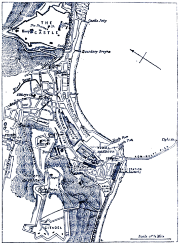
English: Caption: "Plan of Dover."
A map (oriented NE) of Dover, England, c. 1878. |
| Date | |
| Source | "Dover" in the Encyclopaedia Britannica, 9th ed., Vol. VII, pp. 380–1. |
| Author | Anonymous. Presumably engraved by John Bartholomew & Son or William & Alexander Keith Johnston. |
Licensing
This work is in the public domain in the United States because it was published (or registered with the U.S. Copyright Office) before January 1, 1929.
Public domain works must be out of copyright in both the United States and in the source country of the work in order to be hosted on the Commons. If the work is not a U.S. work, the file must have an additional copyright tag indicating the copyright status in the source country.
Note: This tag should not be used for sound recordings. |
| Annotations | This image is annotated: View the annotations at Commons |
File history
Click on a date/time to view the file as it appeared at that time.
| Date/Time | Thumbnail | Dimensions | User | Comment | |
|---|---|---|---|---|---|
| current | 15:47, 20 August 2017 | | 2,962 × 4,000 (10.25 MB) | LlywelynII | User created page with UploadWizard |
File usage
The following 2 pages use this file: