File:Periplus World Map.jpg
Jump to navigation
Jump to search

Size of this preview: 724 × 600 pixels. Other resolutions: 290 × 240 pixels | 580 × 480 pixels | 927 × 768 pixels | 1,237 × 1,024 pixels | 2,142 × 1,774 pixels.
Original file (2,142 × 1,774 pixels, file size: 785 KB, MIME type: image/jpeg)
| This is a file from the Wikimedia Commons. Information from its description page there is shown below. Commons is a freely licensed media file repository. You can help. |
Summary
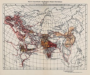
| Description |
English: Caption: 1912 map to illustrate the 60 A.D. Periplus Maris Erythraei Legend: 60 English Nautical Miles = 1 equatorial degree = 600 Olympic Stadia |
| Date | |
| Source | The Periplus of the Erythraean Sea, back flap. |
| Author | Anonymous |
| Other versions |
.jpg)
Licensing
This work is in the public domain in the United States because it was published (or registered with the U.S. Copyright Office) before January 1, 1929.
Public domain works must be out of copyright in both the United States and in the source country of the work in order to be hosted on the Commons. If the work is not a U.S. work, the file must have an additional copyright tag indicating the copyright status in the source country.
Note: This tag should not be used for sound recordings. |
| Annotations | This image is annotated: View the annotations at Commons |
File history
Click on a date/time to view the file as it appeared at that time.
| Date/Time | Thumbnail | Dimensions | User | Comment | |
|---|---|---|---|---|---|
| current | 16:06, 6 February 2019 | | 2,142 × 1,774 (785 KB) | LlywelynII | User created page with UploadWizard |
File usage
The following page uses this file:
Global file usage
The following other wikis use this file:
- Usage on en.wikipedia.org
- Usage on fa.wikipedia.org
- Usage on fa.wikibooks.org
- Usage on fr.wikipedia.org
- Usage on ja.wikipedia.org