systems, causing the formation of numerous lakes and of the waterfalls which determined the situation of many of the manufacturing cities of the state.

|
| Emery Walker sc. |
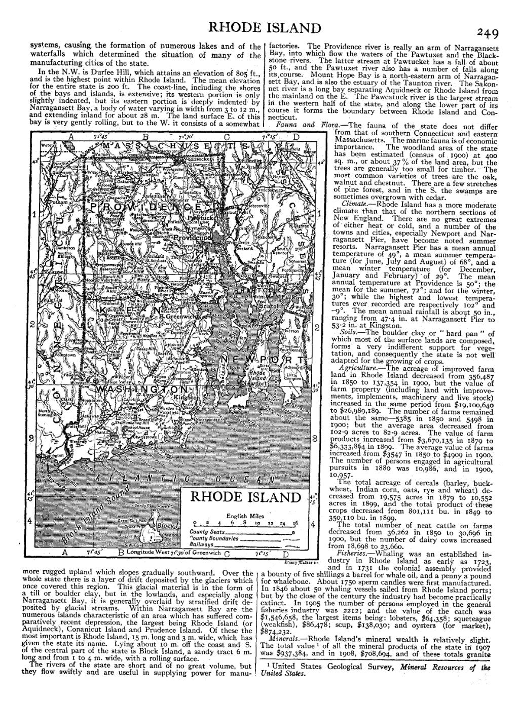
In the N.W. is Durfee Hill, which attains an elevation of 805 ft., and is the highest point within Rhode Island. The mean elevation for the entire state is 200 ft. The coast-line, including the shores of the bays and islands, is extensive; its western portion is only slightly indented, but its eastern portion is deeply indented by Narragansett Bay, a body of water varying in width from 3 to 12 m., and extending inland for about 28 m. The land surface E. of this bay is very gently rolling, but to the W. it consists of a somewhat more rugged upland which slopes gradually southward. Over the whole state there is a layer of drift deposited by the glaciers which once covered this region. This glacial material is in the form of a till or boulder clay, but in the lowlands, and especially along Narragansett Bay, it is generally overlaid by stratified drift deposited by glacial streams. Within Narragansett Bay are the numerous islands characteristic of an area which has suffered comparatively recent depression, the largest being Rhode Island (or Aquidneck), Conanicut Island and Prudence Island. Of these the most important is Rhode Island, 15 m. long and 3 m. wide, which has given the state its name. Lying about 10 m. off the coast and S. of the central part of the state is Block Island, a sandy tract 6 m. long and from 1 to 4 m. wide, with a rolling surface.
The rivers of the state are short and of no great volume, but they flow swiftly and are useful in supplying power for manufactories. The Providence river is really an arm of Narragansett Bay, into which flow the waters of the Pawtuxet and the Blackstone rivers. The latter stream at Pawtucket has a fall of about 50 ft., and the Pawtuxet river also has a number of falls along its course. Mount Hope Bay is a north-eastern arm of Narragansett Bay, and is also the estuary of the Taunton river. The Sakonnet river is a long bay separating Aquidneck or Rhode Island from the mainland on the E. The Pawcatuck river is the largest stream in the western half of the state, and alone the lower part of its course it forms the boundary between Rhode Island and Connecticut.
Fauna and Flora.—The fauna of the state does not differ from that of southern Connecticut and eastern Massachusetts. The marine fauna is of economic importance. The woodland area of the state has been estimated (census of 1900) at 400 sq. m., or about 37% of the land area, but the trees are generally too small for timber. The most common varieties of trees are the oak, walnut and chestnut. There are a few stretches of pine forest, and in the S. the swamps are sometimes overgrown with cedar.
Climate.—Rhode Island has a more moderate climate than that of the northern sections of New England. There are no great extremes of either heat or cold, and a number of the towns and cities, especially Newport and Narragansett Pier, have become noted summer resorts. Narragansett Pier has a mean annual temperature of 49°, a mean summer temperature (for June, July and August) of 68°, and a mean winter temperature (for December, January and February) of 29°. The mean annual temperature at Providence is 50°; the mean for the summer, 72°; and for the winter, 30°; while the highest and lowest temperatures ever recorded are respectively 102° and -9°. The mean annual rainfall is about 50 in., ranging from 47.4 in. at Narragansett Pier to 53.2 in. at Kingston.
Soils.—The boulder clay or “hard pan” of which most of the surface lands are composed, forms a very indifferent support for vegetation, and consequently the state is not well adapted for the growing of crops.
Agriculture.—The acreage of improved farm land in Rhode Island decreased from 356,487 in 1850 to 137,354 in 1900, but the value of farm property (including land with improvements, implements, machinery and live stock) increased in the same period from $19,100,640 to $26,989,189. The number of farms remained about the same—5385 in 1850 and 5498 in 1900; but the average area decreased from 102.9 acres to 82.9 acres. The value of farm products increased from $3,670,135 in 1879 to $6,333,864 in 1899. The average value of farms increased from $3547 in 1850 to $4909 in 1900. The number of persons engaged in agricultural pursuits in 1880 was 10,986, and in 1900, 10,957.
The total acreage of cereals (barley, buckwheat, Indian corn, oats, rye and wheat) decreased from 19,575 acres in 1879 to 10,552 acres in 1899, and the total product of these crops decreased from 801,111 bu. in 1849 to 350,110 bu. in 1899.
The total number of neat cattle on farms decreased from 36,262 in 1850 to 30,696 in 1900, but the number of dairy cows increased from 18,698 to 23,660.
Fisheries.—Whaling was an established industry in Rhode Island as early as 1723, and in 1731 the colonial assembly provided a bounty of five shillings a barrel for whale oil, and a penny a pound for whalebone. About 1750 sperm candles were first manufactured. In 1846 about 50 whaling vessels sailed from Rhode Island ports; but by the close of the century the industry had become practically extinct. In 1905 the number of persons employed in the general fisheries industry was 2212; and the value of the eaten was $1,546,658, the largest items being: lobsters, $64,358; squeteague (weakfish), $86,478; scup, $138,030; and oysters (for market), $874,232.
Minerals.—Rhode Island's mineral wealth is relatively slight. The total value[1] of all the mineral products of the state in 1907 was $937,384, and in 1908, $708,694, and of these totals granite
- ↑ United States Geological Survey, Mineral Resources of the United States.