The special surface weather observation for Guam International Airport for 0147 on August 6 was as follows:
- Wind variable at 4 knots; visibility--5 miles; present weather--light rain shower; sky condition--few 1,500 feet, scattered 2,500 feet, overcast 4,000 feet; temperature 26° C; dew point 24° C; altimeter 29.85 inches Hg.
The Safety Board examined the NWS surface weather observation logs and found that heavy rain showers were reported at the airport between 0020 and 0029, between 0114 and 0116, and between 0153 and 0158. The weather logs also indicated that light rain showers were reported at the airport between 0016 and 0020, between 0029 and 0033, between 0106 and 0114, between 0116 and 0128, and between 0138 and 0148. Further, light rain and mist were also reported between 0148 and 0153. The maximum windspeed recorded at the airport between 0130 and 0150 was about 10 knots.
The following terminal aerodrome forecast (TAF) for Guam International Airport, which was issued by the NWS on August 6 at 0030 as an amendment to an earlier TAF, was valid at the time of the accident:
- Wind 120° at 7 knots, visibility greater than 6 miles, scattered 1,600 feet scattered 4,000 feet scattered 8,000 feet overcast 30,000 feet. Temporary August 6, 0100 to August 6, 0600, wind 130° at 12 knots gusting 20 knots, visibility 3 miles, heavy rain shower, broken 1,500 feet cumulonimbus overcast 4,000 feet.
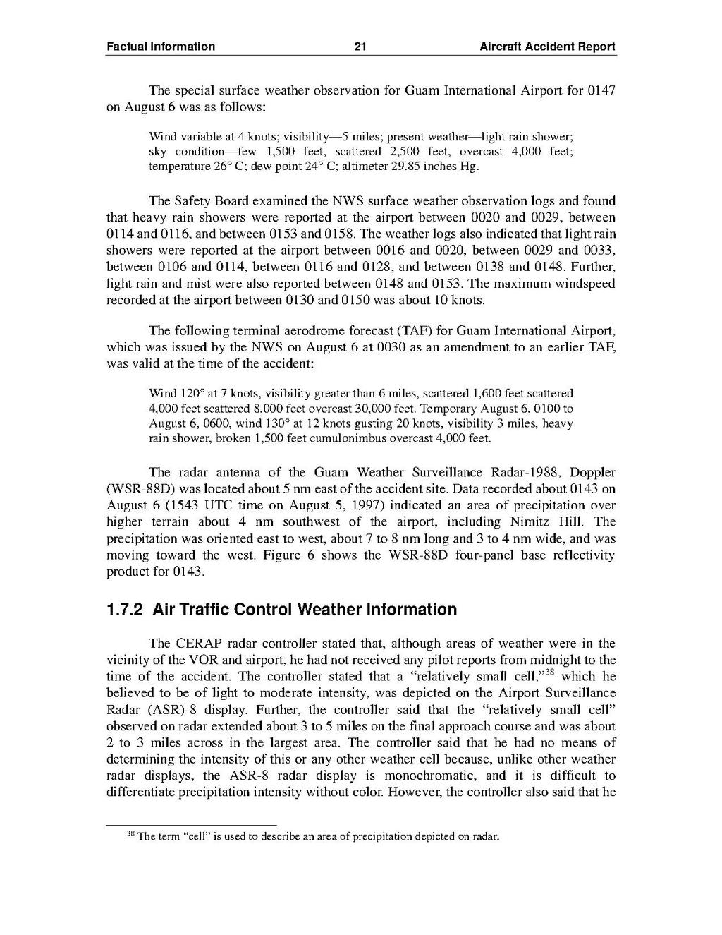
The radar antenna of the Guam Weather Surveillance Radar-1988, Doppler (WSR-88D) was located about 5 nm east of the accident site. Data recorded about 0143 on August 6 (1543 UTC time on August 5, 1997) indicated an area of precipitation over higher terrain about 4 nm southwest of the airport, including Nimitz Hill. The precipitation was oriented east to west, about 7 to 8 nm long and 3 to 4 nm wide, and was moving toward the west. Figure 6 shows the WSR-88D four-panel base reflectivity product for 0143.
1.7.2 Air Traffic Control Weather Information
The CERAP radar controller stated that, although areas of weather were in the vicinity of the VOR and airport, he had not received any pilot reports from midnight to the time of the accident. The controller stated that a "relatively small cell,"38 which he believed to be of light to moderate intensity, was depicted on the Airport Surveillance Radar (ASR)-8 display. Further, the controller said that the "relatively small cell"[1] observed on radar extended about 3 to 5 miles on the final approach course and was about 2 to 3 miles across in the largest area. The controller said that he had no means of determining the intensity of this or any other weather cell because, unlike other weather radar displays, the ASR-8 radar display is monochromatic, and it is difficult to differentiate precipitation intensity without color. However, the controller also said that he
- ↑ The term "cell" is used to describe an area of precipitation depicted on radar.