This page needs to be proofread.
Boundary Lines of Mifflin co.
F³. xxi
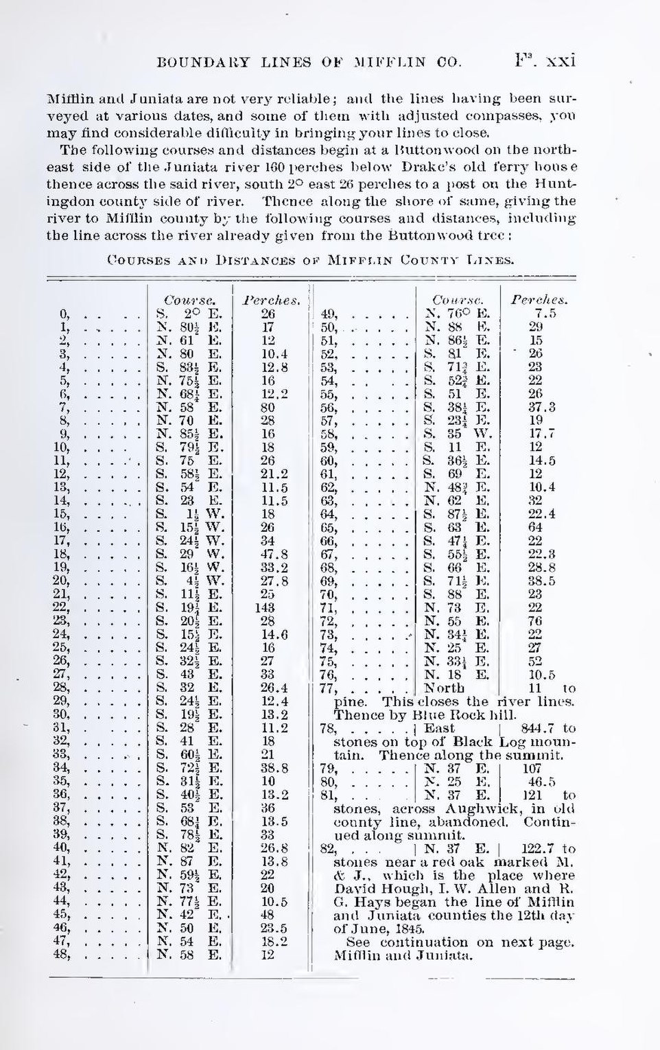
Mifflin and Juniata are not very reliable; and the lines having been surveyed at various dates, and some of them with adjusted compasses, you may find considerable difficulty in bringing your lines to close.
The following courses and distances begin at a Buttonwood on the north-east side of the Juniata river 160 perches below Drake’s old ferry house thence across the said river, south 2° east 26 perches to a post on the Huntingdon county side of river. Thence along the shore of same, giving the river to Mifflin county by the following courses and distances, including the line across the river already given from the Buttonwood tree:
Courses and Distances of Mifflin County Lines.
| Course. | Perches. | Course. | Perches. | ||
| 0, | S | 2 | ° | E. | 26 |
| 1, | N. | 80 | ½ | E. | 17 |
| 2, | N. | 61 | E. | 12 | |
| 3, | N. | 80 | E. | 10.4 | |
| 4, | S. | 83 | ½ | E. | 12.8 |
| 5, | N. | 75 | ½ | E. | 16 |
| 6, | N. | 68 | ¼ | E. | 12.2 |
| 7, | N. | 58 | E. | 80 | |
| 8, | N. | 70 | E. | 28 | |
| 9, | N. | 85 | ½ | E. | 18 |
| 10, | S. | 79 | ½ | E. | 18 |
| 11, | S. | 75 | E. | 26 | |
| 12, | S. | 58 | ½ | E. | 21.2 |
| 13, | S. | 54 | E. | 11.5 | |
| 14 | S. | 23 | E. | 11.5 | |
| 15, | S. | 1 | ½ | W. | 18 |
| 16, | S. | 15 | ½ | W. | 26 |
| 17, | S. | 24 | ½ | W. | 34 |
| 18, | S. | 29 | W. | 47.8 | |
| 19, | S. | 16 | ½ | W. | 33.2 |
| 20, | S. | 4 | ½ | W. | 27.8 |
| 21, | S. | 11 | ½ | 25 | |
| 22, | S. | 19 | ¼ | E. | 143 |
| 23, | S. | 20 | ½ | E. | 28 |
| 24, | S. | 15 | ½ | E. | 14.6 |
| 25, | S. | 24 | ½ | E. | 16 |
| 26, | S. | 32 | ½ | E. | 27 |
| 27 | S. | 43 | E. | 33 | |
| 28 | S. | 32 | E. | 26.4 | |
| 29 | S. | 24 | ½ | E. | 12.4 |
| 30 | S. | 19 | ½ | E. | 13.2 |
| 31 | S. | 28 | E. | 26.4 | |
| 32 | S. | 41 | E. | 18 | |
| 33 | S. | 60 | ½ | E. | 21 |
| 34, | S. | 72 | ½ | E. | 38.8 |
| 35, | S. | 31 | ½ | E. | 10 |
| 36, | S. | 40 | ½ | E. | 13.2 |
| 37, | S. | 53 | E. | 36 | |
| 38, | S. | 68 | ¼ | E. | 13.5 |
| 39, | S. | 78 | ½ | E. | 33 |
| 40, | N. | 82 | E. | 26.8 | |
| 41, | N. | 87 | E. | 13.8 | |
| 42, | N. | 59 | ½ | E. | 22 |
| 43, | N. | 73 | E. | 20 | |
| 44, | N. | 77 | ½ | E. | 10.5 |
| 45, | N. | 42, | E. | 48 | |
| 46, | N. | 50 | E. | 23.5 | |
| 47, | N. | 54 | E. | 18.2 | |
| 48, | N. | 58 | E. | 12 | |
| 49, | N. | 76 | ° | E. | 7.5 |
| 50, | N. | 88 | E. | 29 | |
| 51, | N. | 86 | ½ | E. | 15 |
| 52, | S. | 81 | E. | 26 | |
| 53, | S. | 71 | ¾ | E. | 23 |
| 54, | S. | 52 | ¾ | E. | 22 |
| 55, | S. | 51 | E | 26 | |
| 56, | S. | 38 | ¼ | E. | 37.3 |
| 57, | S. | 23 | ¼ | E. | 19 |
| 58, | S. | 35 | W. | 17.7 | |
| 59, | S. | 11 | E. | 12 | |
| 60, | S. | 36 | ½ | E. | 14.5 |
| 61, | S. | 69 | E. | 12 | |
| 62, | N. | 48 | ¾ | E. | 10.4 |
| 63, | N. | 62 | E. | 32 | |
| 64, | S. | 87 | ½ | E. | 22.4 |
| 65, | S. | 63 | E. | 64 | |
| 66, | S. | 47 | ¼ | E. | 22 |
| 67, | S. | 55 | ½ | E. | 22.3 |
| 68, | S. | 66 | E. | 28.8 | |
| 69, | S. | 71 | ½ | E. | 38.5 |
| 70, | S. | 88 | E. | 23 | |
| 71, | N. | 73 | E. | 22 | |
| 72, | N. | 55 | E. | 76 | |
| 73, | N. | 34 | ¼ | E. | 22 |
| 74, | N. | 25. | E. | 27 | |
| 75, | N. | 33 | ¼ | E. | 52 |
| 76, | N. | 18 | E. | 10.5 | |
| 77, | North | 11 to pine This closes the river lines. thence by Blue Rock hill. | |||
| 78, | East | 844.7 to stones on top of Black Log mountain. Thence along the summit. | |||
| 79, | N. | 37 | E. | 107 | |
| 80, | N. | 25 | E. | 46.5 | |
| 81, | N. | 37 | E. | 121 to stones, across Aughwick, in old county line, abandoned. Continued along summit. | |
| 82, | N. | 37 | E. | 122.7 to stones near a red oak marked M. & J., which is the place where David Hough, I. W. Allen and R. G. Hays began the line of Mifflin and Juniata counties the 12th day of June, 1845.
See continuation on next page. Mifflin and Juniata, | |