File:SomersetSouth.png
Jump to navigation
Jump to search
No higher resolution available.
SomersetSouth.png (200 × 101 pixels, file size: 6 KB, MIME type: image/png)
| This is a file from the Wikimedia Commons. Information from its description page there is shown below. Commons is a freely licensed media file repository. You can help. |
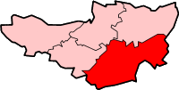
South Somerset district in Somerset
Created by en:User:Morwen

|
Permission is granted to copy, distribute and/or modify this document under the terms of the GNU Free Documentation License, Version 1.2 or any later version published by the Free Software Foundation; with no Invariant Sections, no Front-Cover Texts, and no Back-Cover Texts. A copy of the license is included in the section entitled GNU Free Documentation License. |
| This file is licensed under the Creative Commons Attribution-Share Alike 3.0 Unported license. | ||
| ||
| This licensing tag was added to this file as part of the GFDL licensing update. |
File history
Click on a date/time to view the file as it appeared at that time.
| Date/Time | Thumbnail | Dimensions | User | Comment | |
|---|---|---|---|---|---|
| current | 13:58, 8 February 2010 | | 200 × 101 (6 KB) | Mahahahaneapneap | Transparent background |
| 15:11, 24 May 2006 |  | 200 × 101 (10 KB) | Nichtbesserwisser | South Somerset district in Somerset Created by en:User:Morwen {{GFDL}} Category:Maps of districts in South West England |
File usage
There are no pages that use this file.
Global file usage
The following other wikis use this file:
- Usage on bg.wikipedia.org
- Usage on de.wikipedia.org
- Usage on en.wikipedia.org
- Yeovil
- Ilminster
- Ilchester
- South Somerset
- Somerton, Somerset
- Chard, Somerset
- South Cadbury
- East Coker
- Castle Cary
- Crewkerne
- Yeovilton
- Merriott
- Montacute
- Martock
- Ashill, Somerset
- Wincanton
- Abbas Combe
- Templecombe
- Aller, Somerset
- Barton St David
- Langport
- Chiselborough
- Dowlish Wake
- Alford, Somerset
- Ansford
- Ash, South Somerset
- Babcary
- Barrington, Somerset
- Barwick, Somerset
- Beercrocombe
- Bratton Seymour
- Brewham
- Broadway, Somerset
- Bruton
- Brympton
- Buckland St Mary
- Chaffcombe
- Charlton Horethorne
- Charlton Mackrell
- Charlton Musgrove
- Chillington, Somerset
- Chilthorne Domer
- Chilton Cantelo
- Closworth
- Combe St Nicholas
- Compton Dundon
- Compton Pauncefoot
View more global usage of this file.