Washington, DC: United States Government Printing Office, pages 138–142
3985505Interregional Highways — Appendix II. Location of other highway systems of various mileages investigated by the committee1944National Interregional Highway Committee
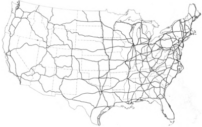
APPENDIX II
Location of Other Highway Systems of Various Mileages Investigated by the Committee
Figure 1.—The 14,300-mile system investigated by the Public Roads Administration in connection with the report Toll Roads and Free Roads, sent to Congress by the President in 1939.
Figure 2.—The 26,700-mile system tentatively proposed as an interregional highway system by the Public Roads Administration in the report, Toll Roads and Free Roads.
Figure 3.—The 29,300-mile system investigated by the Public Roads Administration as an interregional system and described in Public Roads, June 1941.
Figure 4.—The 48,300-mile system, consisting of the more important routes of the 78,800-mile system.
Figure 5.—The 78,800-mile system. This is the largest system investigated by the Committee.