Transactions of the Geological Society, 1st series, vol. 4/On the Parallel Roads of Glen Roy
XVIII. On the Parallel Roads of Glen Roy.
By the J. Mac Culloch, M.D. F.L.S.
president of the geological society,
Chemist to the Ordnance,
Lecturer on Chemistry at the Royal Military Academy,
and Geologist to the Trigonometrical Survey.
The extraordinary and hitherto solitary phenomena which I
have undertaken to describe, although long known and celebrated
by the natives as the traditional works of their great ancestors, remained
concealed from the world in general till Mr. Pennant published
a short account of Glen Roy in an appendix to his Tour.
A second description appeared in the Statistical Survey of Scotland,
since which I know not that any attempt has been made to explain
the origin of the Parallel Roads, although they have long been
objects of curiosity to philosophical as well as to ordinary tourists.
However convinced the Highlanders may have formerly been that
these parallel roads, as they are called, were the works of Fingal
and the heroes of his age, they have lately inclined to a different
belief, and with most philosophers are willing to think that they
may have been the result of the action of water. Still the matter
remains disputed among the partizan's of the different theories, and
as the establishment of the latter opinion is attended with geological
consequences of the first importance, it deserves to be investigated
with the greatest care.
The appearance of the parallel roads is so extraordinary as to impress the imagination of the most unphilosophical, nay, even of the most incurious spectator. It is not therefore surprising that they should excite the admiration of the natives, in whom the progress of civilization has not yet extirpated those poetical feelings and that sense of the sublime, of which their literary relics still afford us proofs.
On each side of a long, hollow, deep valley, bounded by dark and lofty mountains, and at a great elevation, three strong lines are traced, parallel to each other and to the horizon, the levels of the opposite ones coinciding precisely with each other. So rarely does nature present us in her larger features with artificial forms, or with the semblance of mathematical exactness, that no conviction of the contrary can divest the spectator of the feeling that he is contemplating a work of art, a work, of which the gigantic dimensions and bold features appear to surpass the efforts of mortal powers. We cannot therefore wonder that the solitary and poetical Highlander, educated amid mountain storms and hourly conversant with the sublime appearances of Nature, should attribute to the ideal and gigantic beings of former days a work which scorning the mimic efforts of the present race, marches over the mountain and the valley, holding its undeviating course over the impassable crag, and the destroying torrent.
But it is the duty of the philosopher to investigate causes. I
purpose therefore to give as ample and detailed a description as I
was able to draw up, of the appearances themselves, and afterwards
to examine the several modes of explanation which have been
offered; stating the arguments for and against the different hypotheses
as amply and as distinctly as I can, and deducing from the
balance of probabilities such conclusions as the evidence appears to justify. The necessity of investigating their probable or possible
origin from natural causes will, in consequence of the extent of
their geographical connections, lead to rather a wide range of
enquiry, not however wider than the importance of the subject
will be found to justify. I have attempted to keep clear of all speculations
purely hypothetical, and wherever physical evidence and
analogy have entirely failed, have rather chosen to leave the question
in its natural obscurity than to involve it in more profound
darkness by assigning imaginary causes. To avoid any bias which
the original and not sufficiently descriptive term, Parallel roads,
might preserve in the reader's mind, I have substituted that of
Lines, a term less exceptionable and sufficiently expressive of their
appearance.[1]
Before examining any of the theories which have been proposed to explain the singular appearance which this glen exhibits, I have judged it expedient to describe with as much accuracy as possible the appearances themselves, without entering on the question of causes, or prejudging in any degree the case. In thus describing it, I have preferred beginning at the source of the river, or rather at the commencement of the valley, since the rivers which form the Roy arise as mountain torrents, forming a junction in the middle of a valley of considerable magnitude.
A low hill of granite skirts the boundary between the source of the Spey and the valley of the Roy. At the foot of this hill, in a slightly elevated boggy plain, is found Loch Spey, which by a declivity for some time scarcely perceptible runs eastward through Badenoch to fall into the Moray firth. The western end of the boggy plain just mentioned stretches for a few hundred yards beyond the head of Loch Spey, and then descends by a sudden step into the upper valley of Glen Roy. This valley is of an oval form, about four miles in length and one or more in breadth, being bounded on two opposite sides by high mountains. From them descend two streams which unite about the middle of the valley to form the Roy. From this junction the water flows with a moderate velocity for a space of two miles, when the glen suddenly contracts and terminates in a rocky hill of low elevation. The water, forcing its way for some distance through a narrow pass between approaching rocks, enters into a second glen, which I shall distinguish by the name of the lower Glen Roy. It is in this latter glen that the phenomenon of the roads is chiefly to be seen, nor on entering the upper from the lower one would it be suspected that any similar appearance existed in it. A line however may be observed on the left hand extending upwards from the junction which forms the Roy, along the face of a low hill towards the elevation in which Loch Spey lies. A careful examination of this line by the spirit level shows it to consist of a level narrow terrace, which if prolonged eastward would cut the perpendicular above Loch Spey, and if continued westward would meet the summit of the flat rock that forms the division between the higher and lower Glen Roy. It will speedily be seen that this summit is on a level with the uppermost of the lines in lower Glen Roy, and that the terrace which I have now described is in fact a prolongation of that line. It is necessary to remark that no other terrace or line is found in the upper valley.[2]
The flat rock already mentioned as forming the gorge of lower Glen Roy, or the division between the upper and lower vallies, is seen projecting at right angles to the right hand side of the glen, and then turning westward so as to form a promontory parallel to that side; having a cul de sac on one hand and giving passage to the river on the other. No line is visible on the rock itself, but from its junction with the side of the valley (as the plan will show)[3] the two lines commence, and are seen running on far along the face of the hill, the uppermost one being precisely even with the flat parts of the surface of the rock just described. It is proper here to remark that the surface of this rock rises higher in some places than that line, yet it is not marked by any corresponding one. The drawings accompanying this paper will render intelligible that which words alone cannot describe; and I must here premise once for all, that this minuteness of description, however superfluous it may at first sight appear, is absolutely required, as the circumstances thus dwelt on will be of essential use in investigating the cause of the appearances under discussion. It is by an attention to circumstances which at the first glance appear trivial, that abstruse truths are often discovered; and it is precisely where leading and obvious phenomena offer no clue to guide us, that a ray of light will often be thrown on the subject from appearances at first neglected. Had the greater features of Glen Roy been capable of explaining the singular phenomena which it exhibits, this paper would have perhaps been altogether superfluous, since all observers would have been agreed respecting their causes.
These level and parallel lines are scarcely to be seen in this place, except by looking from below upwards, a position by which they are foreshortened to the spectator's eye. They may sometimes indeed be distinguished (but with more difficulty) if viewed in profile. In the part which I am now describing the lines are narrow and the declination of their surfaces from the horizontal plane is considerable, as the profiles[4] will show. This ground is rocky and irregular, the natural rock being visible in many places, while in the rest of the glen it is but rarely seen; and it may be remarked that wherever the natural rock comes to light these marks or lines are always least discernible, being of much smaller dimensions, and having a much greater conformity in their slopes to the natural slope of the hill. Whatever loose matter occurs here consists of large fragments, which have evidently descended from the hill above. That this is their origin and that they are not transported materials is plain, since they are not rounded and since they exactly resemble the natural rock, which is of a remarkable character, consisting of mica slate traversed by numerous veins of red granite; a rock which is limited to the upper part of the glen and is not found in the neighbouring hills. The natural rock projects in many parts of the line so as to interrupt it; or it is wanting wherever a solid mass of rock occurs in its course. As I am here only describing the appearances, I will not anticipate the arguments by asking whether the line has not been sometimes overwhelmed by the fall of rubbish; in many cases however its obscurity evidently arises from the refractory nature of the materials on which it is traced. Obscure marks of two similar lines are here and there visible on the left hand side in this place, particularly on certain projecting faces where the surface of the hill is, from its outline, evidently covered with a coat of alluvial matter. Independently of these fragments of the two principal lines, many short indistinct traces are to be seen at different levels from those on which these two lie. It is here necessary to say that the two lines on the right now described are parallel to each other, and correspond precisely in level with the fragments of the two upper ones visible on the opposite side.
As we proceed down the glen a river is seen entering at the left hand equal in size to the Roy, and falling into it by a cascade which rushes over a rocky bed. Here a great series of terraces is found, forming a large terreplein at the top of this glen which I have called lower Glen Roy. These terraces are of different levels, as may be seen both in the section[5] and in the views that accompany this paper.[6] The highest of them will hereafter be proved to lie on a level with a third line, to be described in the course of this investigation. It falls off however by many successive stages of terraces, and numerous smaller ones are also to be seen descending down to the very bed of the river, skirting its banks and accompanying its course. The bottom of the glen is here an alluvial flat, as the above mentioned section will show. Between the two upper lines on the right hand an intermediate one now becomes visible for a space of about half a mile: I did not measure it, but to the eye it appears equidistant from both. At this point the two lines now described suddenly quit the rocky face described on the right hand, and continue their courses along the alluvial slopes of the declivities which follow; where also they acquire their greatest breadth and distinctness.
I forbear giving the breadths in all the places where I measured them, because it is not important. The profiles will show the principal varieties.[7] In detailing their measures I must remark that it would be impossible to describe the precise geographical point measured, and such often is the curvature at the entering and salient angle, or at the inner and outer edge of the line, that no precise limit for the measure of breadth can be assigned; different modes of measurement may therefore produce differences of many feet.[8] It is sufficient if they agree generally, and in general sixty feet may be assumed as an average breadth: by far the largest portion of all the lines will be found to conform to this measurement.
Great terraces are now visible on the right. These are not precisely on the same level with that which I before mentioned as corresponding to the course of a third and lower line, but they do not differ materially from it.
I shall not describe the various rivers which enter the glen, the principal ones being marked in the plan, but may mention that in this upper part of the valley, both before and at the junction of Glen Turit with Glen Roy, they are generally accompanied by their own lateral terraces.
On the left hand going down the glen many marks or fragments of lines are seen between the principal ones; but these are short, and are remarkable for many obscurities and deficiencies. In a few places there are errors of level to be seen in the lines. Examining these however there appears no doubt of their having been produced by partial subsidences of the whole alluvial face; and this is confirmed by the appearance of one great slide on the left, which has descended many feet, and which the imagination can readily replace. It is necessary to be cautious in examining these instances of errors of level, as the laws of perspective are apt to lead to mistake when the lines pass curved surfaces elevated high above the horizon.
Where the faces of the hills have been furrowed by the long continued action of descending torrents, the lines enter these hollows for a certain space; and as this rule is general, it is unnecessary either to describe the spots or to mark the exceptions, but the fact itself is important. They are often ploughed across or obliterated by torrents obviously recent; and they sometimes also terminate abruptly in more ancient torrents; but still the two upper ones continue generally traceable and commonly very well marked: for the rest I must again refer to the plan.[9] From these appearances we can often ascertain the relative difference of age between the hollow or torrent and the line: and we can also in some cases distinguish that a part of one hollow is prior and a part posterior to it. It may be remarked generally that the lines are best marked on the straightest sides, or on those slopes which lie in a straight or a slightly curved plane, while they are most obscure where the most numerous sinuosities, torrents, irregularities, or rocky faces occur. Among the best marked are the two uppermost ones on the right hand above Glen Turit, one of those at the head of Glen Turit, and the three above Glen Fintec on the same side. About two miles below the head of lower Glen Roy, a semi-circular cory or hollow opens on the right, giving rise to a considerable stream and falling gradually into Glen Turit. The two upper lines (for as yet there are no more) enter it a little way and then disappear. On its opposite side, or that which adjoins to Glen Turit, appear three marks offering the only considerable anomaly in the whole course of these lines. The two uppermost, which on a superficial view seem to be the continuation of the two before described, will be found more distant from each other than these, and on applying the spirit level to them it is seen that the lowest is continuous with the upper one of Glen Roy, but that the highest is a supernumerary one, although of the same apparent dimension and form, and that it terminates abruptly at both ends. That one which is continuous with the upper line of Glen Roy is prolonged into Glen Turit. Of the lower one I unfortunately neglected to remark, from the multiplicity of objects calling for attention at the same time, whether it was anomalous, or whether, as it appears to the eye, it is not continuous with the third and lowest in Glen Roy. I shall forbear pursuing their course into Glen Turit, as the description of this glen will find its proper place hereafter.
Passing over therefore the description of this glen, a great accumulated mass of terraces similar to those in the upper part of Glen Roy is seen at the junction of the two streams which issue from it, and from the small glen or cory whose name I could not discover, but which is delineated in the map.[10] The compound mass offers a surface of different heights, but the highest of them corresponds precisely in level with the highest terraces at the top of Glen Roy, and equally so with the lowermost line of the three for which Glen Roy is remarkable, and which now first appears continuously on the right side, having been some time visible, though in an imperfect state, on the left. The minor terraces which skirt the river are also visible here, and accompany it for a considerable space downwards along the bottom of the glen, which still continues to present an irregular alluvial flat; but as it is sufficiently marked in the plan and sections, I need not enter into further details respecting it.[11] The accompanying views[12] will also afford an additional and a much better illustration than any description could do.
Independently of these compound and minor terraces which are accumulated below the lowest line, there are also fragments and parts of irregular terraces in various places at a level above it, besides considerable channelled alluvia forming a sort of conoidal segments on the faces of the hill, and appearing to be the remains of more regular terraces furrowed and destroyed by the mountain torrents. Although the two upper lines are to be traced at the salient angle opposite to Glen Turit, they are interrupted and obscure to the very top of the valley. It is important to remark that the glen here takes a turn,[13] forming a considerable angle, the opening of Glen Turit being not far from the re-entering one. At the salient angle the lowermost line is first seen, as on the right side it first is found at the entrance of Glen Turit, into the wide opening of which it runs, together with the upper ones, for a very short space; the whole of them speedily disappearing on this side of that glen, while on the contrary side the upper one runs well marked until its course is suspended by the gradual rise of the bottom of the valley.
Having, at this part of Glen Roy arrived at the point where three lines on each side are visible, it is time to observe that there is a perfect correspondence of level between the opposite pairs wherever they are found. Numerous trials with the spirit level confirm the universality of this rule, and from this point of the glen downwards to its junction with Glen Spean, I did not observe that any one instance occurred of even the little anomalous curvatures which I have already mentioned as happening in the upper part of the valley. They are in many places entirely wanting, as the plan will show, and as will be mentioned hereafter, but where ever they are present they obey the law. It is to this circumstance they owe that aspect of parallelism from which they have derived a part of their name, but which evidently can be a parallelism only in the vertical plane. The varying slope of the hills prevents all parallelism in the horizontal one, and causes, as will be readily comprehended, the distance between any two approximate ones to vary exceedingly, a circumstance of importance in examining some of the speculations which have been formed relating to their cause and origin. In these circumstances it would be as useless as it would be difficult, to give the measures of their variations. It is sufficient to remark that the nearest horizontal distance between the uppermost and nearest lines may be taken at 150 or 160 feet, and the greatest between the two lowermost and most distant ones at 1000; an approximation sufficiently accurate for the purpose. But the vertical distances as ascertained by the spirit level are 82 feet between the uppermost and second, and 212 between the second and lowermost. I have omitted fractions in this measurement, because the irregularity of the ground is such, and the uncertainty of the true surface of the line so great, that it is impossible to determine this point to a great nicety. The slope of each line is likewise so considerable, and at the same time so various, that a great variation of this vertical distance would take place according to the point adopted as the station of the spirit level, and I have therefore fixed it at the middle of each line. I need not here call the reader's attention to the distances between the uppermost line and the top and bottom of the glen respectively, as these will fall more properly to be considered when the general levels of the surrounding vallies and outlets are examined.[14] For the same reasons the aspect and materials of the lines themselves will be best considered when I have described the mineralogical structure of the whole glen, and particularly that of the surfaces on which they are formed.
Having passed Glen Turit, the three lines now become distinct and well marked on the right side, where the hill is covered with a thick alluvium: on the opposite side they are also distinct, although here and there slight appearances of irregularity, and supernumerary marks occur. The bottom of the glen continues to exhibit an alluvial flat for about three miles from the entrance of Glen Turit downwards, and the terraces which are always found bordering this flat, gradually disappear as the bottom of the glen contracts. A few interruptions occur here and there, apparently connected with the rockiness and irregularity of the ground, and these are most remarkable on the right side; but shortly before the glen turns to the south, and until we arrive at Glen Fintec, all the three lines are strongly marked on both sides. On the slope of a brown hill in this place they are particularly worthy of remark, on account of their continuity, preservation, and the almost absolute equality of their dimensions, not only through the course of each individual line, but respectively to each other.[15] This is easily accounted for by the evenness both of the curvature and inclination of the plane of the hill on which they are marked, as well as by the form of its summit, which diverts the water courses in such a direction as to preserve that surface from their action. It is important to remark this equality, as it proves that the causes which produced these lines, have been similar and equal, and that the irregularities now to be met with are the result, not of irregularities in the action of the power by which they were produced, but of inequalities in the capacity of the ground on which these causes have acted.
At this place an elevated glen opens into Glen Roy on the right. No water enters into it from this valley, but the junction is formed by a dry plain extending for some space, which, declining gradually in the opposite direction, carries its waters towards Glen Gloy, with which it also communicates. As the bottom of this glen is, at its entrance, at a higher level than the lowermost of the lines, this latter is here interrupted; but the two upper ones enter it on each hand, and are continued for some way along its sides. It is unnecessary to pursue the course of this glen further, as it adds no illustration to the subject; but it is necessary to remark, that not only at the angles and curvatures of these lateral glens, but at the turns which the principal valley Glen Roy itself makes, the breadth and form of the lines is equal every where, as well below as above the curvature. The breadth of the bottom of the valley here has been for some time reduced to an angle;[16] and the strath, or alluvial flat, which characterized its upper part, has ceased. The hills on the left hand side descend with various curvatures and irregularities, but the three lines continue well marked on them as far as Glen Glastric, on the north side of which they turn up for a short space, and then disappear. Below Glen Fintec all the three are visible as far as a stream which enters the Roy nearly opposite Glen Glastric, and here the uppermost disappears. The rapid fall of the Roy has now increased the distance between the lowermost line and the foot of the glen, as the section will show.[17] A material alteration here takes place in the aspect of the sides of the glen, but most particularly on the right. A great range of deep alluvium is seen between Glen Fintec and Glen Glastric, the upper surface of which is not far below the lower line, bearing marks of a level once continuous, though now much interrupted.[18] This waste is owing to the action of mountain streams, which have ploughed it deeply to the very river, forming a great range of semiconoidal hillocks, similar to those which I mentioned as occurring in the upper part of the glen, but much more remarkable.
It is here necessary to notice that the alluvium at the top of the glen which covers the sides of the hills, consists of sharp fragments with a mixture of clay, a bed precisely similar to that which occurs so generally on the declivities of mountains, and which, from the unworn nature of the fragments, and their identity with the rocks above, appears evidently to have resulted from the wearing down of the summits. But the terraces themselves at the top of the glen vary in composition, and though often composed of the same sharp fragments that overspread the general declivity, they occasionally also exhibit various rolled and transported matters. The conoidal hillocks which I have just mentioned, as occurring between Glen Fintec and Glen Glastric, are of a very different composition. Numerous sections of them are to be seen, the result in some cases of a road lately made, in others of the action of water. By these they are shown to consist of deposits of fine sand, gravel, clay, and rolled stones of different sizes, disposed in a manner irregularly stratified, and in a direction more or less horizontal. The terraces and hillocks which occupy positions much inferior to this all the way along the course of the Spean to its entrance into the Lochy, are of the same materials.
I could perceive no traces of any lines on the left hand, from Glen Glastric downwards, for a space of about two miles. No reason for this deficiency appears, either in the form or composition of the ground. On the contrary it possesses that gentleness of slope and curvature, and that uniformity of alluvial surface on which, in the upper parts of the glen, the lines are always most deeply marked. Nor does it give rise to any streams to the action of which their loss and disappearance might be attributed. Were it not that a similar interruption occurs at a lower point down the glen, as well as in the other vallies connected with it, we might at first suppose that the acting cause had here terminated. It is in no respect different from many of the upper parts of the glen on which the roads are marked, except in the gentleness of its slope. Yet this is insufficient to account for the deficiency, as the appearance becomes again visible on hills below it of a slope precisely similar. It must at present therefore be regarded as one of the numerous difficulties attending this very difficult subject.
The upper line becomes also invisible on the right opposite to this place, and shortly after, the whole disappear on this side, though no material alteration takes place in the form or structure of the hills. About a mile before we arrive at the junction of the Roy and Spean, the valley expands, and here the lowermost line again makes its appearance, continuing its course round Meal Derig to the side of Glen Spean, where it disappears. The same line shortly after reappears on the right side, and from hence it can be traced with more or less difficulty as far as Teindrish, over a various surface of very slight inclination, until it finally vanishes. At Keppoch the Roy falls into the Spean issuing from Loch Laggan, and here it loses its name; while the Spean holds its course westward for a space of five or six miles till it falls into the Lochy.
On the left bank of the Spean, near the junction of the Roy, a line is visible which is found by the spirit level to correspond with the lowermost line of Glen Roy. It runs about three or four miles up the valley over a surface of moderate inclination, yet although the curvature and structure of the opposite hills which bound the Spean are similar, it is not found on the right bank. It continues to hold its course westward with more or less obscurity, from the junction of the Roy and Spean along the declivities of the high mountains Ben na 'chlianach, Scuir rinish, and Carn derig, which bound this wide valley to the south, finally disappearing opposite to Teindrish, and nearly in the same meridional direction. The valley is here of such dimensions that the opposite lines are about four miles asunder. Its bottom is extremely irregular, offering rather an accumulation of low hills than a valley properly so called. But in no place does the altitude of these hills rise to the level of this lowest line; a fact which it will be necessary to keep in mind when we enquire into the causes that have led to the formation of these lines. It is also necessary to remark that through this wide and irregular space there are no streams of any note, but that the whole is drained in an almost imperceptible manner into the only river which traverses it; the Spean. The opening of this valley is wider than its mean dimension, since it gradually and imperceptibly loses itself in the great valley of the Lochy, which forming a wide plain, at length terminates in the sea at Loch Eil.[19]
Before examining the distant connections of Glen Roy it is necessary to return to its more immediate ones; as in them alone the traces of the lines are marked. Having already mentioned all that was required relating to Glen Fintec and Glen Spean, it only remains to describe Glen Turit, which I deferred lest it should interrupt the more important account of Glen Roy itself.
I mentioned that towards the upper part of Glen Roy two glens entered by wide openings, bringing in two tributary streams to the Roy. One of these, of inconsiderable extent, has already been sufficiently described. The other, Glen Turit, forms a communication between Glen Roy and Glen Gloy, rising between the two and discharging its waters on both sides. Where it falls into Glen Roy it is at so high a level as to exclude the lowermost of the lines. Traces however of the two upper ones enter its mouth, on the right hand side of which (looking from the source of the water) they speedily and suddenly disappear. But on the left, besides a short trace of the second, a line is to be seen extending for the space of a mile or more on a level with the uppermost in Glen Roy, until it is cut off by the rising of the bottom of the glen. This is among the best marked of those which are any where to be found, its breadth being not less than 70 feet and its inclination among the least of those which I measured. It is important to notice that the opposite sides of Glen Turit are very little dissimilar either in shape or composition, although they do not exhibit equal traces of the lines; and it is still more essential to remark that the bottom of this glen is of solid rock and not of alluvial formation; since in the course of the examination it will be important to remember that the operation of ordinary causes is to diminish, not to augment its elevation.
Where this solitary line disappears in consequence of the rise of the glen, a level space occurs without a stream, but in no long time it produces one, which running westward forms the water of Gloy and enters Loch Lochy beyond Lowbridge.
When I said that the upper line which is prolonged so far into this glen is stopped by the rising of its bottom, I did not intend to speak precisely: it ceases in fact for some space before, but evidently from the sliding of the face of the hill into the stream. That which it is important to note is, that if it had been prolonged it would have met the bottom of the glen, which may be considered as there forming an intermediate hill between Glen Gloy and Glen Roy, and thus interrupting the continuous level which should take place between them at the height of the upper line, It is this part of the fact alone which is important, and important in more views than one, as will appear when I shall attempt to investigate the cause of these lines. I may remark that these altitudes are not estimated, but were observed by the spirit level.
I have reason to regret that a tempestuous season prevented me from examining Glen Gloy with the same care which I had bestowed on Glen Roy. The requisite observations, attended with difficulties sufficiently perplexing in the latter case, were rendered impracticable in the former, while the nature of the past summer, 1816, and that of the preceding, 1815, not less unfavourable in the western highlands, have made it utterly impossible to renew the investigation, originally made in 1814.
From this cause I am unable to assert positively that there is an identity of level between the lines of Glen Roy and those which occur in Glen Gloy, although it will hereafter be seen that there is but little, if any, reason to doubt it. I shall describe the appearances as far as I was able to observe them; when the reasons for acquiescing in their common origin will appear.
On entering Glen Gloy from Lowbridge no trace of a libe can be perceived for about three miles. The marks of three are then to be seen on the salient angle of a green hill on the left bank of the stream. As far as the eye can judge of their relative distances (for I was unable to measure them) they appear to correspond to those of Glen Roy: but the upper and lower one soon terminate, while the middle one is continued for some little way up the valley. On the right side of the stream, opposite to them, a very strongly marked line of considerable breadth occurs, extending up the valley for a long space beyond the reach of the eye, accompanied by an inferior one far less persistent.
Being prevented from tracing this valley into Glen Roy, I attempted
to examine it in the opposite direction by entering from
Glen Turit. I have shewn that the lines of Glen Roy terminate
at the head of Glen Turit, in consequence of its elevation by which
their progress is at length naturally terminated. From this point
which separates the head of this glen from that of Glen Gloy, since
it is the common boundary of both, no line can be seen for a space
of three or four miles; at which point one commences on the right side, which according to my information extends far towards the
bottom of the glen, and is therefore continuous with that one which
I examined from its mouth. The principal question with regard
to this line is, whether it corresponds with the uppermost or with
the second of Glen Roy. I attempted to determine it by the spirit
level and by the barometer. The former observations were so
much impeded by the weather that I am unwilling to place any
reliance on them, since the vertical difference of these two lines
being little more than 80 feet, considerable nicety would be required
in carrying on the levels. From the barometric observations
it appears that the difference of level between this upper line of
Glen Gloy and that of Glen Roy is only 12 feet, a difference that
may fairly be attributed to errors of observation. It is probable
therefore that these two are on the same level, while there seems
abundant reason to conclude, from the general similarity of proportion
between the intervals of those in Glen Gloy and those in
Glen Roy, that the former have originated from the same cause as
the latter, and admit of the same general train of reasoning which
will hereafter be applied to these. If any doubt should remain, in
consequence of the want of more positive evidence, it must be
remembered that the lines of Glen Roy have been shown to enter
Glen Spean, and also to be prolonged through the common wide
valley in which both these rivers terminate; that the situation of
Glen Gloy is by the intervention of Glen Lochy analogous to that
which Glen Roy holds to the common valley of the Spean and
Roy; and that on a calculation of chances it is almost infinitely
improbable, that the apparently corresponding proportions of the
three lines of Glen Gloy are not actually corresponding, and sufficient
to prove, if not a former continuity between the levels of
the different vallies, at least a common cause for all.
In terminating this description I may remark, that the topographical deficiencies which may be found in it are irremediable until an accurate geographical survey of this country shall be made, but that these deficiencies can not materially affect the arguments about to follow, whatever additions they may chance to make to them.
In as far as the mineralogical structure of the country is concerned in the description of the lines of Glen Roy, I have already noticed the principal facts in describing the nature of the alluvia which form the surfaces of the hills. I may however proceed to say, that the natural rock is not often visible on their faces, although it may be observed in most parts of the bed of the river. I have already briefly remarked that at the upper part of the valley it consists of a hard micaceous schist traversed by veins of red granite. The same rock is continued upwards towards the source of the Spey till the granite itself appears; which forms the most elevated part, and that only, of the country between the sources of the Spey and of the Roy. But in proceeding from the head of Glen Roy to its mouth, the granite veins gradually disappear; various sorts of schist, micaceous, quartzose, and argillaceous, occurring in an irregular order and at various elevations. The beds are sometimes to be seen absolutely horizontal, and at others as completely vertical; and I need hardly say that they occupy all the intermediate angles. A similar construction extends through Glen Gloy, and along the sides of Loch Lochy, as well as the skirts of Ben Nevis.
The different opinions which have been entertained relative to the origin of these lines, or Roads, as they have most commonly been supposed, render it necessary to describe their form and materials; which the accompanying sections, with the aid of a few words, will render easily intelligible. There is no need for the pickaxe and spade to investigate this question, since the water courses have produced innumerable natural sections; recent ones may be found after every fall of rain, a circumstance in which Lochaber is by no means deficient.
The extreme breadth of these lines may safely be taken at seventy feet, or a little more, and their most general one lies between that and fifty. As in no instance that I have remarked do they exceed the former, so they very rarely indeed fall short of the latter dimension. The most remarkable exception to this rule has been already noticed in describing the upper part of the glen; and it may not be amiss to repeat that the lines are narrowest and least marked on the hardest and most rocky ground, where in fact they cannot, with any latitude of language, be called roads, since they are absolutely invisible to a person when standing on them. In no case is their surface level, but it lies at various angles with the horizon, from 30° and upwards to 20° and 12°.[20] It is probably from this cause that they are in many cases invisible where we should otherwise expect to find them; their own inclination coinciding so nearly with the general slope of the ground as to render them imperceptible from the place of the spectator.[21] Both the interior and exterior angles are very much rounded;[22] and the surface, I need scarcely add, is marked by considerable inequalities, from the fall of stones, and the partial accumulation of plants and recent soil. In describing their relation to the side of the hill, they may be said to bear the resemblance of sections of parallel layers applied in succession to its face.[23] In only one instance is there a slope, resembling a superior talus, and this is visible for perhaps half a mile;[24] while in no instance did I perceive the marks of an inferior one. But the profiles now referred to, which were selected among the most remarkable ones, will represent these several circumstances better than they can be described by words.
With regard to their structure I can only say, that it does not appear to me calculated to throw light upon any system respecting their origin. When they are found on those faces of hills where the rubbish is sharp, they consist of sharp materials; where it consists of transported materials, they are formed of rounded gravel and sand. Whatever hypothesis of their formation may be adopted, it is evident that this circumstance can throw no light on it; as, whether they are the effects of nature or of art, they must have been formed in and of the materials in which they exist.
Having thus described Glen Roy itself with the lines for which it is distinguished, and pursued its connection with the neighbouring vallies, it is necessary to extend our views, and to trace its connection with the sea.
The glen itself opens by a wide mouth, as I before said, into the great valley which stretches between the northern and western sea, and which is the seat of the Caledonian canal. This opening is so gradual that its breadth cannot be defined, but it may be conceived to vary from five to seven miles. The whole of this space is uneven and hilly, consisting of rocky elevations and alluvial deposits. The Spean flowing through it and falling into the Lochy forms one deep section, but no other water courses are found in it, either direct or lateral; such at least as exist are of very insignificant dimensions. On applying the spirit level to a great many points through this wide space they were all found inferior to the lowest line of Glen Roy, with one or two trifling exceptions. The opening of Glen Spean, as must have already been remarked, like that of Glen Roy, has the same direct and present communication by means of the Lochy with the western sea.
The opening of Glen Gloy is narrow, but its communication at Lowbridge with the long valley now described, is at a point somewhat higher in elevation than that at which Glen Spean enters, since its water falls into Loch Lochy, the source of the river of the same name.
Tracing therefore the course of this valley, into which Glen Roy and Glen Gloy open, we find it communicating with both seas. Its highest level is at Loch Oich, the point from whence the waters decline in two directions, and this elevation is ninety feet above that of the sea at Loch Eil. Besides the waters issuing from Glen Roy and Glen Gloy, it receives at various points to the south-westward of its summit level, the streams which issue from Loch Eil, Loch Arkeig, and numerous smaller glens, while on the north-eastern slope it is the receptacle of the waters of Loch Garry, Glen Morrison, Fyers, Glen Urquhart, and others of less note. Hence it appears that its upper level is inferior by 886 feet to the lowest line of Glen Roy, and by 1180 feet to the uppermost, the height of the upper line of Glen Roy being found from barometrical measurement to be 1262 feet above the level of the western sea. Examining now the glens which communicate laterally with this great valley, we shall find that they are all situated on the western side. They are Glen Morrison, Glen Urquhart, Glen Garry, the glen of Loch Arkeig, and that of Loch Eil.
From want of time for so laborious an undertaking, I am unable to describe either the disposition or the elevations of the four first of these branches, but have reason to think that they all rise at their western ends to levels higher than those of the lines in Glen Roy. Fortunately it is not material with regard to the general results that must follow from considering the phenomena of Glen Roy, since these will be still nearly the same although these glens had not existed. The glen of Loch Eil however, which I have examined, requires a more detailed description, as it is probably implicated in the consequences which will follow from one of the theories that must be had recourse to in explaining the appearances of Glen Roy.
The valley of the Spean and that of the western branch of Loch Eil may be considered as opening into the great Caledonian valley by a common wide mouth; while the southern bend of Loch Eil lies in a valley comparatively narrow, formed by the skirts of Ben Nevis on one side, and the hills of Ardgowar on the other. It is necessary to keep this circumstance in mind till the probable causes of the lines in Glen Roy are brought under review. A valley of a dead level extends to the head of Loch Eil, which being little higher than the loch is of course elevated but a few feet above the sea, of which its water forms a branch. From the head of this loch another gentle rise conducts to the head of Loch Shiel, a fresh water lake, which occupying a narrow prolonged valley, at length descends by a gentle declivity into the sea at Loch Moidart. I cannot give the elevation of Loch Shiel, which is nearly the highest point of this level, but from an estimate formed on the ground, which at any rate cannot be so far in error as to affect the question, conclude it to be inferior to all the lines of Glen Roy, the lowest of these being 976 feet above Loch Eil. Water therefore, if we could now imagine it raised to the levels of the lines of Glen Roy, would run to the sea at Loch Moidart, as well as at Loch Eil, and at the Moray Firth.[25]
Returning to the head or eastern communication of Glen Roy, we find that it is divided into two glens separated by a partial rocky barrier through which the river forces its way, and that the summit of this barrier is on a level with the uppermost line. But in describing the upper glen I showed that it bore the marks of a line level with the uppermost one of lower Glen Roy, and consequently both continuous with it, and produced by a common cause. It is important to remark this fragment of a line, as, on the supposition of a continuous water level it removes the boundary of the water from lower Glen Roy to a point further east. But the next eastern point which forms the present boundary of the head of upper Glen Roy is the source of the Spey, and this elevation separates the great eastern declivity of the water at this point, or the valley of the Spey, from the western one, or that of the Roy. The measurements made by the spirit level, as well as the observations of the barometer, prove that the source of the Spey is 63 feet lower than the upper line of Glen Roy. If therefore we recur to the same supposition that water could now be accumulated to that level, it is plain that it would flow easterly into the valley of the Spey, as well as into the western outlets just enumerated.[26]
If we now turn to the remaining communication of Glen Roy, which is with the valley of the Spean, we shall find that this river flows with no great declivity from Loch Laggan to its junction with the Roy, a space of seven miles or thereabouts. The length of Loch Laggan is ten miles, and it is separated at its upper part from the valley of the Spey by a barrier of low rocks, and by a plain of nearly four miles in length, which conducts a sluggish stream into the Spey at a point about ten miles from its source. As on the east side of this barrier the waters are directed to the Spey, so on the west they are directed to Loch Laggan. The barrier itself gives no rise to waters, as it consists of a narrow ledge of rocks; nor does it appear at any time to have been liable to suffer from the course of rivers. This is a species of judgment which can be formed without perhaps any great risk of error, by inspecting the positions and shapes of rocks and mountains, but it is a judgment of which the grounds can scarcely be explained by drawings or descriptions. The observation itself is of importance in examining the general theories of the appearances in Glen Roy. Circumstances prevented me from ascertaining the actual height of this barrier above the sea, and the nature of the ground does not admit of any direct levelling to it from Glen Roy, without a series of most intricate and tedious operations, which would in fact be unnecessary in examining the question. But by comparing its level with that of the Spey at the point where the before mentioned sluggish stream joins that river, and by computing the elevation of that point from Garvamore of which the height was ascertained, its altitude is readily estimated to a sufficient degree of accuracy for the present purpose.
Comparing these heights therefore it will be found that the barrier of Loch Laggan to the east is depressed 369 feet below Loch Spey and 432 feet below the uppermost line of Glen Roy. Supposing therefore that the water stood at the highest elevation in Glen Roy in the present state of the earth, it would run into the Spey not only by the channel of Loch Spey, but by that of Loch Laggan also.[27]
Such are the communications which Glen Roy has with the surrounding country, and through that with the sea. I have described them with all the minuteness in my power, as they are of the first importance in the investigation of the causes which are to be assigned as giving rise to the lines of Glen Roy; and as the important geological consequences which follow the most probable of these theories, could only be deduced from a consideration of their extended connections. In thus describing them I have been in some measure compelled to anticipate some of the arguments hereafter to be adduced, however inclined to preserve the description distinct from the reasonings; and this for the purpose of laying a due stress on the facts of most importance, and of more effectually directing the attention to those on which the reasonings must hereafter be founded.
The first, and not long ago the most popular, nay the only hypothesis was that from whence these lines have derived their name of Parallel Roads. They were conceived to be roads made for the purposes of hunting, either by the Feinne, or by certain kings of Scotland, who were supposed to have resided at Inverlochy Castle, which is situated not many miles distant on the banks of the river Lochy. The arguments which are used to prove this opinion may be divided into two classes; tradition, and some physical appearances to be found in the lines themselves, combined with certain applications to the purpose of hunting, of which they are supposed capable. It is vain to inquire into the æra or history of the Fions, whether they existed at the time of Severus's expedition, or at a period prior to that, since rational antiquaries have given up the point in despair. Nor are the traditions concerning their connection with these roads, even if we admit their existence at some remote period, such as to demand any acquiescence in this conclusion. It is said that the hills of Glen Roy are named after the heroes or dogs of this favourite and poetical age; from Gaul, and Diarmid and Fillan, and the celebrated Bran. But this is a circumstance not peculiar to Glen Roy. The same names are applied to hills in Glenco, in Glen Lyon, and in many other places; while the very tombs of these heroes which occur in so many different parts of Scotland would prove that they possessed an ubiquity even after death.
Equally idle traditions are recorded concerning certain hollows now to be seen in Glen Turit, which are supposed to have been constructed for cooking their venison, and which go by the name of Coir na Fion; the kettles of Fingal. But admitting that tradition were to be received as evidence in such a case as this, it is not difficult to show that even tradition is at variance with itself. For they have been equally attributed to certain Scottish kings who are supposed to have resided in Inverlochy Castle.
The date of this building is much too modern to admit of any connection between it and the appearances in question, were they even ascertained to be roads. It is a quadrangular structure occupying an area of about 1600 yards, and like Harlech and others of the Welsh castles of Edward's time, consists of four curtains with flanking towers at the angles. The height of the curtain is from 25 to 30 feet, and that of the towers from 40 to 50. The scarp extends to a distance of 12 feet from the foot of the wall, and the whole is surrounded by a moat, once wet, 40 feet in breadth. It has two principal gates, one to the land and another which appears to have extended to the water. Sally ports and loop holes are also to be observed in the towers, some of the latter being intended to cover the sally port and others to flank the curtain. Remains of a building which seems to have been intended for a drawbridge are also visible. This construction altogether, not easily misapprehended by antiquaries, to whom the marks of age more or less distant are visible in ancient military works in more circumstances than those which I have now pointed out, shows that it cannot be referred to a very remote origin. The largest and western tower is called the Cummin's tower. The name however is not of itself sufficient to prove that this castle appertained to the Cummins, or that it was erected by that once formidable Clan, whose ancient fame and power have, like those of Fingal himself, associated its name with buildings and transactions in which it might have been no way concerned: yet its aspect would not induce us to refer to it to a date higher than that of Edward I. the period in which the power of that clan was in its greatest splendour. There is an idle tradition that it had been a seat of Bancho, head of the race of Stuarts, and that a league had been signed there by Charlemagne and Achaius about the end of the eighth century. But authentic records show that Bancho was not the ancestor of the Stuart family; nor was it possible that Bancho, had he existed, could have been a Thane of Lochaber; since that district was not at this remote period under the dominion of the kings of Scotland. The history of Achaius and his treaty with Charlemagne, so far from being merely involved in obscurity, has been shown by learned antiquaries to be a fiction.
So far do the arguments from tradition reach. Let us next enquire, tradition apart, whether there is any thing either in the physical construction, the disposition, the antiquity, or the alledged uses of these lines, which can justify the supposition that they are works of art. The magnificence of the object itself, when considered as a work of art, is such as to impose on the judgment by heating the imagination; and it is not therefore wonderful that such a notion should have been maintained with considerable pertinacity by remote highlanders, whose traditional belief in the power and splendour of their heroic ancestors, although fast expiring, is by no means entirely obliterated. But the phenomenon is of too great magnitude and importance to admit of such a solution without a more strict species of evidence; or, in defect of that evidence, of such collateral and circumstantial proofs as can be deduced from its present appearance and connections, from the probable motives in which it may have originated, and from the contrary deficiency in probability of other assigned causes. It is said that they were roads made for the purposes of hunting the deer: such are the assigned motives. Admitting them, it is necessary to examine how far this pursuit was likely to be aided by the contrivance in question. Two practices are chiefly in use in this chace. The first of these is to approach the deer while in their pasture or at rest, by such circuitous ways as to protect the hunter equally from their acute scent or their sight; a practice known by the name of deer-stalking. The other consists in driving them by a power of men or dogs, or both, in such a direction as to pass the stationed hunter, who thus shoots them in their course. Another notion has however been maintained relative to the method of hunting in this place and in those times. It has been imagined that the roads were fenced with stakes on each side, and used as a sort of decoy, into which the deer were driven, to be afterwards shot at leisure by those who were stationed without.
It is impossible to conceive that they were used as stations from whence to shoot deer at rest, since a fixed point must be unavailable in this variety of the chace, and since the exposure of the hunter himself would render the invention useless. For similar reasons they could be of no use in driving the deer, as the herds must necessarily pass in the greater number of cases so as to be out of bow shot. Although in the upper parts of the glen the distance from the lowest line to the bottom of the valley is trifling, yet at its lower part that distance becomes far greater than the range of an arrow. It is equally evident that it could not have been any part of the design of this work to bring the supposed roads within a limited and fixed distance, as although the vertical distance of the lines is equal, their horizontal one varies extremely according to the inclination of the ground, so that approximate lines which are in some cases but 100 feet asunder will in others be separated to 1000 and more.
If we consider them lastly as intended for a species of decoy it will be necessary to discover by what means the deer were to be enticed into them: the hunters who now drive the forests of Ben Gloe or Mar would smile at him who should attempt to drive a herd of deer into a fenced lane. In fact they bear no resemblance to any practicable species of decoy, and we have fortunately still preserved in the island of Rum vestiges of a real decoy used for this purpose. It appears to have consisted of two stone dikes arising high in the hills and gradually contracting in their dimensions till they terminated in a tall circular enclosure, in which the deer were at length confined and killed. It may be added finally that the great number of these lines as well as their proximity are also arguments against this notion.
Viewing them indeed in the most vague light as roads, even if we do not attempt to assign an object for them, they are either deficient in the qualities which a road requires, or they do not exhibit the marks by which it would be characterized, or lastly they are arranged in a manner so capricious as to render a motive for their disposition unfathomable.
Wherever the hill is formed of a soft alluvium they possess the greatest breadth, while, on the contrary, wherever the ground is rocky, they are scarcely to be traced. It is plain that they should, if they had been roads, have exhibited superior permanence in the most durable materials. We cannot escape this objection by saying that they have been wasted by time; since that time which has diminished the hardest should have obliterated the softest. If we examine their profiles (of which numerous representations are here given) we shall also see that they bear no resemblance to a work of art. There is no inferior talus, nor, except in one solitary instance which I have noticed, is there any mark of a superior one. They are stairs, if I may use such a comparison, on the face of the hill. It may be answered that the natural decay of the road would consist in the sliding down of the upper talus into the road, so as gradually to diminish its slope and to fill the interior angle, while a similar waste of the lower one would round the exterior or salient angle. But if we examine the final result of this double waste, we shall see that when this ultimate ratio of equality is established throughout the upper and lower talus and the natural slope of the hill, the road must disappear altogether, instead of maintaining, as it often does, a breadth of 70 feet upon an uniform slope of the face of the hill. There is another circumstance in their construction equally repugnant to this hypothesis. In no one instance is the surface level, or even nearly so, as the profiles will show.[28] The least angle which I discovered was one of 12° with the horizon, and more generally they vary from 20° to 30°. This is an effect which could not readily have taken place had they been originally level, as the permanent regularity of their surfaces shows that they have undergone very inconsiderable changes since their first formation.
Their capricious arrangement, if considered as works of art, is equally an objection to the notion of their having been intended as roads. Numerous and crowded in some places they are totally absent in others, and that even where no wasting causes appear to have existed. It may be added perhaps to these objections, that the difficulty of maintaining a water level throughout the whole connection of this interrupted and distant set of lines, is such as would require a knowledge of engineering and the possession of methods which we can scarcely concede to times so rude; and that the want of bridges of communication where they are interrupted by torrents, of which no traces can be discovered and of which the knowledge could scarcely then have been in existence, must have rendered them useless as roads. Nor ought we to pass over another circumstance which I have noticed in describing them; that towards the top of the glen many marks are found precisely similar in dimension, level, and general aspect, but running through short spaces and at levels different from those of the supposed roads. These are alone sufficient to point out a different cause, and when considered together with the terraces which I have already shown to be continuous with one of the lines, they indicate some action of water as the real cause of this phenomenon. Into the different modes by which this action might have produced them I shall now proceed to enquire.
The visible and demonstrable marks of a continuous set of water levels throughout the whole of these lines, has very naturally given rise to the notion that they have been the result of the above mentioned cause at some distant period. The nature of this action is however by no means very easy to assign, and as the several views which may be taken of it are attended with consequences more or less difficult of explanation, and at any rate of very extraordinary importance in a geological view, it is necessary to examine into the various ways in which this agent might have produced these effects, instead of remaining content with a vague and general idea of their having originated in such a cause. Only three modes of explaining the action of water in producing these lines occur, and they are all derived from phenomena of which we see or imagine the causes going hand in hand with the effects. These phenomena are not uncommon in mountainous countries, and must be familiar to those who are intimate with the highlands of Scotland.
The sudden and rapid rise of a torrent when fed by the streams from the neighbouring hills, is marked by lateral devastation and ruin, wide in proportion as the materials of the hills are subject to be removed and transported by the rapid flow of the water. Clay, gravel, and stones thus transported are deposited in banks which skirt the course of the torrent at the level of its highest elevation, often continuing to mark that course to future times, till a fresh flow of water rising to a higher level destroys them or substitutes higher banks in their places. A partial deluge is but a torrent on a greater scale, and we can therefore conceive this phenomenon extended in its magnitude and consequences, but producing a similar set of appearances. This cause has been supposed to have produced the lines of Glen Roy.
The banks of the Spey, of the Lyon, and those of almost every river running through a flat alluvial valley in Scotland, or (to make use of an expressive Scottish term,) a strath, exhibit the appearance of terraces, at different elevations and distances from the present course of the stream, which have an abrupt edge resembling the profile of an earthen military defence. The numerous elevations which these terraces assume in any one valley, prove that the cause by which their surfaces have been levelled has acted at various successive intervals downwards; while their variously placed lateral sections equally show that the cause of their waste at the sides has acted at many different periods laterally. If we now attend to the course of a stream through an alluvial and flat valley of this nature, we find it gradually, often imperceptibly, but sometimes suddenly changing its position in consequence of partial obstructions produced by the transportation of rubbish. Thus while it is engaged in deepening its own bed it is also changing its horizontal place, undermining its bank on one side and in succession quitting it to attack some other point; while at the same time it is flattening a larger portion of the plane on which it flows than the breadth of its own water, and reducing it to one uniform broad space. Thus a terrace with a profile is formed and left at a distance from the course of the stream; while a series of such capricious changes, acting through a considerable space of time both horizontally and vertically, fills the bottoms of the straths with terraces so numerous and complicated as almost to bewilder us in attempting their explanation. Such a cause may be conceived to have produced the lines in Glen Roy. We must imagine the glen filled to the depth of its upper level with alluvial matter, and suppose that a wasting stream has held its course through it for a space of time so long as to remove the whole matter to its present depth, leaving the lines which are now marked on its sides, together with the terraces that are to be seen at its upper end, as memorials of its destroying force. This is the second hypothesis depending on the action of water which has been offered in explanation of the appearances in Glen Roy.
The third and last method of explaining these appearances by the the same agent, is founded on the form assumed by the alluvial matter which in many cases is found at the edges of a lake, and on the probable consequences which would arise from draining it. On this view it is conceived that a lake had existed at the uppermost level of Glen Roy, for so long a period as to have accumulated on its margin that alluvium which now forms the uppermost of the lines in question, and that, by a subsequent sinking through two successive and similar periods, the two lower ones had been formed in the same manner. As the sinking of the waters must have been the consequence of the failure of some barrier by which they had been confined, it is plain that considerable changes of the surface are requisite for the solution of the present appearances, as well on this supposition as on either of the former ones, although these changes must be of a different nature.
Each of these hypotheses is attended with considerable difficulty, and involves consequences as important in a geological view as they are unknown in our ordinary experience. Arguments enough have perhaps been brought to show that they could not have been works of art; and among the natural causes which present themselves I know not that any others can be produced but the three now mentioned. It is our duty therefore to examine the probabilities attached to each of these, and to chuse among them that whose ordinary effects offer the fewest discrepancies from the actual appearances under review. If the whole of the phenomena are still difficult of explanation under any system which we may adopt, we must have recourse to the method of dilemma, and at least reject those assigned causes which involve impossibilities. If it shall finally appear that an impossibility is attached to each, we shall be driven back to allow their origin in human art and labour; since this hypothesis involves at least no physical impossibility, though assuredly a very high degree of moral and physical improbability.
The first hypothesis which has been proposed to explain the appearances in Glen Roy is the action of a deluge, or rather of a series of large and powerful torrents. There must in fact have existed three torrents at distinct periods, as the nature and distances of the several lines obviously require such a series of causes. It is neither necessary nor convenient to examine the general principle on which this explanation proceeds, as it would lead into discussions foreign to the views of this paper, and as it is undoubtedly supported by a sufficient mass of evidence.
It is proper however before entering on this examination to recall to the reader the general disposition of the lines, and that of the vallies which they occupy. They are found commencing within a very short distance of that summit which is the common origin of the waters of the Spey and Roy, the one running to the east, the other to the west. In their progress westward they increase in number and in the perfection of their forms and markings, maintaining the same level throughout: while the bottom of the valley, now the course of the Roy, descends with a rapid declivity towards its junction with the Spean. One of these lines is found ascending the valley of the Spean for a few miles, and terminating in the great common valley of the Spean and Roy, at a point agreeing with that of its corresponding line which descends from the valley of the Roy. From Glen Roy the same lines are continued into Glen Turit, a valley opening into that of the Roy. Here they meet with its bottom as it rises during their level progress, but they are renewed in Glen Gloy, a valley placed in a reverse direction to Glen Turit, continuing throughout its descent in a course similar to that which they held in Glen Roy, until they disappear near its lower extremity and before its junction with the vale of the Lochy, the common exit of Glen Gloy and the conjoined vallies of the Roy and Spean.
We are now to examine the probable course of the torrent or deluge assumed to be the cause of these lines. It is most consonant to the present state of things to imagine that it flowed from east to west or from the source of the Roy towards its termination. If it be conceived to have flowed in the reverse direction from the west to the east, or from the present lowest level of the country to the highest one, it will be seen in the course of the argument, that many of the facts bear equally against the possibility of this supposition; to such an extent indeed as to render it quite unnecessary to enter into a formal refutation of it.
The cause of such a deluge or torrent as is here supposed, is generally assumed to be an elevation of a portion of land, elevating at the same time the superincumbent waters. I shall as far as possible simplify the phenomena, and thus give all the assistance I can to this hypothesis by supposing that with one line only, no other valley but Glen Roy exhibited that appearance. A single elevation of the site of Loch Spey would therefore be the only change required to produce the effect. But the fall of the country to the east, and the present course of the Spey show, that a wave produced by this cause must have equally tended to flow in the contrary direction or into the present valley of the Spey, and consequently to leave its impressions to the eastward as well as to the westward of its origin, on the supposition that the form of the surface was then similar to its present one. But no such impressions exist, although the form of the present valley of the Spey is fully as capable of receiving them as that of the Roy; and there are no reasons to suppose any material changes in the shape and disposition of that valley. No water courses either antient or recent, nor any agents are to be seen, capable of destroying these remains if they ever existed. Nor is it possible to comprehend by what means a wave produced at the present elevation of Loch Spey could have formed the first line which is visible in the upper Glen Roy. It is evident that the quantity of water carried by the assumed wave must have been sufficient to have filled the whole of Glen Roy for a course of twenty miles or upwards. It must have consequently stood at a considerable height above the present level of Loch Spey, the seat of the supposed elevation. Yet the first line is found within a few hundred yards from this spot, and at an elevation so little above it that it must necessarily have been buried far under the imagined wave; which could not produce this effect on a surface immersed deeply under it, since the universal pressure of the fluid would produce an equilibrium of actions: nay the very hypothesis supposes them to have been formed by the deposit of loose matters at the surface of a fluid in motion. If the assumed causes which this hypothesis requires are, even with all the simplification and assistance which can be given to them, scarcely reconcilable to the appearances of the country and the ordinary course of Nature, the difficulties become insurmountable when we recollect that it is requisite to adopt a series of such causes; a succession of three similar elevations at given distances of time, producing similar and equal effects under an inequality of circumstances so obvious as scarcely to require mention to those who have reflected on the appearances described in the first part of this paper. Although a more general and distant origin for the supposed diluvian wave should be assumed, the hypothesis is still subject to the difficulties now enumerated; since the obstruction to its course, formed by the elevated ground which confines Loch Spey, would equally prevent it from exerting the requisite actions on the parts beyond that obstacle. It may appear unnecessary to adduce further arguments against this hypothesis, but as one of the objects of this paper is to point out the circumstances applicable to other enquiries of this nature, should such occur hereafter, it will not be useless to enumerate the remainder. Different cases may require different modes of investigation, and that argument which is sufficient for the present may not be universally applicable, as the peculiar objection here examined may not always exist. The investigation moreover is that of a subject but little attended to, and consequently admitting some prolixity of illustration.
It is plain that a set of changes acting through a considerable space of time posterior to the present disposition of the ground had taken place before the water marks were impressed on its sides. This evidence consists in the marks of the lines which are traced to a certain depth on the furrows now possessed by mountain torrents, and which I have fully described in other parts of this paper. By these it is proved that the torrents existed previously to the causes which produced the lines, and, from what we may see of the actions of similar torrents in this or in other places, we are assured that a long period of time had elapsed between their original flow and the subsequent changes which produced the marks of the lines now visible in them. It is equally clear that the formation of these furrows must have been posterior, even though they had been produced in a short space of time, to the great changes, such as the breaking up either of the crust of the globe or of portions of it, which must be assigned as the cause of these deluges; and it is impossible that a series of such violent actions as would generate a deluge of this nature, could have taken place in the immediate vicinity of Glen Roy without obliterating these furrows and deranging all the signs of a previous state of repose.
The intermediate marks which are found at the upper part of the glen afford another argument against the hypothesis of a deluge. Supposing that three torrents consisting of very different quantities of water had flowed with such equable force as to have produced the three principal lines, we have, between the two upper ones, another so slightly marked that it must needs have resulted from a force very inferior to that which generated those below it. Yet it must have been, on this supposition, produced by a mass of water greater than that which caused these, and we can have no reason for supposing that flow attended by a less velocity. That three currents so different in depth should have been propelled with momenta capable of producing effects so equal, is in itself a supposition considerably improbable; but among the other more obvious difficulties attending this explanation it is unnecessary to dwell on this in particular.
The form, dimension and equality visible throughout the whole, present additional obstacles to the supposition that a deluge was the cause of these lines. Among the numerous difficulties which occur in attempting to solve their formation on this view, it is perhaps a trifling one, that three successive torrents should produce three deposits of alluvial matter, of which the sections should be so generally equal and similar: there are many of a more serious nature. I have shown that the deposits in the upper part of the glen in which the lines are traced, are of sharp materials mixed with fine clay, while at its lower part they consist of rounded matter mixed with sand and gravel. If the deposit which occupies the glen had consisted of foreign substances introduced by the flow of a torrent, it should have been formed of rounded matter throughout: in any case there should have been a similarity between the two. Nor is there any reason why it should not be equally found on hard and rocky ground as on a soft surface, since the forms and inclinations of the hills are so often alike.
It is an objection still more serious to this hypothesis, that the thickness and disposition of the alluvia should not be affected by the angular direction of the valley, and by the deviations from a direct line to which it is subject. If we conceive a current flowing through a channel of a bent or zigzag form, it is obvious that its impression on the opposed angles at the point of flexure must be different. Where the salient angle occurs it is plain that it will be more subject to the effect of the water on the side which opposes the current, than on that which declines from it. The same effect will take place at the re-entering angle, but the corresponding sides about the angle will be affected in the reverse order. If therefore the current consists of a mixed mass of earth and water, the principal deposit will be found to leeward of the salient angle, while the windward side (if we may use this metaphorical term) will, remain clean. A similar effect, but in a reverse direction, will take place on the re-entering angle, which however will be more marked by the want of deposit on the side opposed to the stream, than by any accumulation on the other side that includes the angle. But if the current should have consisted of water alone, acting on a previously deposited alluvium, the effects will be of a contrary nature, since the greatest impression will, on both angles, be produced on the side that opposes the stream. Similar effects, but in a more marked degree, must take place wherever such sinuosities and furrows occur as to form a shelter to the sides from the direct action of the current. Yet we have seen that the lines are traced at the numerous indentations and flexures which Glen Roy exhibits, with a total disregard of this circumstance, and with a degree of equality that would have been impossible on such a supposition.
Another argument of a nature somewhat similar to this may be found in the form of the upper part of Glen Roy, already fully described, and to render it the more tangible, it is illustrated by a plan and section.[29] Here the form of the ground produces a complete shelter from the action of any current, which, like that supposed, must have been directed from the east. If we even imagine it directed from the west it must have failed to make the impressions there existing on the right side, or the cul de sac would at least, have been filled with loose materials.
In describing the openings by which Glen Turit and Glen Fintec communicate with Glen Roy, I pointed out a circumstance of which I meant to make use in this argument. I remarked that the bottom of Glen Fintec rose to such a height as to exclude the lower line, and that the bottom of Glen Turit was so high, at no great distance from its entrance into Glen Roy, as to exclude the whole three. With regard to the former I believe that it consists of rock, and cannot therefore have gained its present height by the deposition of alluvial matter posterior to the time at which the lines were formed: with regard to Glen Turit I am certain of this fact. It is plain therefore that no current could have flowed from Glen Roy through Glen Fintec at the level of the lowermost line, nor through Glen Turit at that of any of the three; yet the lines are impressed on the sides almost to the very point where they meet the elevated bottoms of these glens; an effect which, on the supposition of a current, would be impossible. The rocky nature of the bottom of Glen Turit also proves, as far as this valley is concerned, that its former was like its present state; or at any rate, that it has not been elevated by an alluvial deposit since the supposed flowing of the waters; the only supposition which could affect the validity of the argument that I have attempted to deduce from it.
It is in the next place necessary to inquire in what respect the effects of a deluge can be made to correspond with the absolutely level position which the lines of Glen Roy present; as I have already considered the other modifications which the action of water flowing through a channel of varying breadth and figure must receive. As the varying dimensions of the valley cannot be easily computed, it is unnecessary to examine the question with hydro-statical accuracy: a general inquiry as to the probable effects will be sufficient.
A general notion of the difference of capacity of the different parts of Glen Roy, may be acquired from comparing its vertical and lateral dimensions at its extremities; [30] and for the sake of simplicity I shall limit myself to this single case, although it is obvious that many more complicated considerations must enter into the account. It will also be most simple to assume the lowermost line as the groundwork of this investigation, as we here get a minimum ratio. This cuts the rocky bottom of the valley near its uppermost extremity.[31] A point therefore exists in the valley where its vertical dimension, considered from its bottom to the summit of the lowermost line is nothing, its breadth being in that place about half a mile. If now we examine its lower extremity, or that part of the joint valley of the Roy and Spean, where the last point of the same line is visible, we find it situated at a considerable height (not less than 800 feet) above the bottom of the valley, while its breadth is in this place five miles. The simple statement of this fact renders it superfluous to say that a body of water could not flow through a valley of this form, with a level surface; a condition required to produce the line in question. It is plain that the same objection applies to the case of the two upper ones, although with somewhat less force, according to the ratios of the several inequalities at their upper and lower extremities.
As connected with this last argument we may now ask, by what system of operations, on the same hypothesis, the lines were traced on Glen Spean and Glen Gloy. If the solitary line of Glen Spean was produced by the action of a current, it is difficult to conceive that of the three separate lines marked in Glen Roy by one common to both glens, only a portion of the lowest, and that for a short space, should be visible in Glen Spean.
The case of Glen Gloy is still more difficult. I have shown that the head of this valley, by which it communicates with Glen Roy, is obstructed by such a rise as to exclude a free communication at this junction, of the whole of the lines of the latter. No current could therefore pass from Glen Roy into Glen Gloy, since its bottom, as I have also shown, is of ancient and hard rock, not a recent formation. If then there was a current common to both these vallies, the communication must have been formed by the opening of Glen Gloy through the intervention of Loch Lochy. A stream of water must therefore have run from a point where it had either a free exit, or at least a wide space in which to diffuse itself, to one whence there was no exit, and with a velocity as great in the most difficult as in the most easy circumstances, since the lines of Glen Gloy, wherever they exist, are at least as deeply impressed as those of Glen Roy.
The last inquiry to be made on the supposition that these lines are the consequences of a deluge, is, into the origin of the water which flowed through the valley, a subject on which I was compelled in some measure to enter at the beginning of this argument, but of which the whole difficulty could not be appreciated without including Loch Laggan in the investigation; a tract of which the importance could not then have been so readily understood. The views which I have formerly given of the level of this lake, and of that of Glen Spean, show that this supposed point must be removed far to the eastward, without which the waters could not have flowed through Glen Spean at the same time as they flowed through Glen Roy. This case is even more complicated than the one stated at the beginning of the argument, it being impossible that a deluge of this sudden nature and great magnitude could have taken place so as to include Loch Laggan, without changes in the surface of the earth at this place and beyond it, even greater than those which I first pointed out.
I shall not pursue the consequences of this hypothesis further. Every person's imagination can supply additional difficulties, which it would be tedious to follow to their ultimate ramifications.
The next hypothesis which has been offered in explanation of the lines of Glen Roy is, that they are the remains of water terraces similar to those which are of common occurrence in the alluvial straths of Scotland.
Almost all the rivers, whether of greater or smaller dimensions, that flow through these straths with small velocities, or over planes of moderate inclination, are accompanied by lateral banks lying at a distance from the actual bed of the stream. They may in fact be considered as the deserted banks of the river itself, which in forming a deeper course for its waters has at the same time changed its ground laterally, leaving its ancient bed deserted and bounded by one of the banks which formerly confined it, while the other has been undermined and carried away by its opposite lateral deviation.
The ancient bank thus assumes the form of a terrace, with a slope resembling that of a military work, and standing at that angle which the peculiar circumstances of the soil enable it to maintain. Where the action of the river has been such as to cut its way, constantly deepening, through an alluvial plain, the surfaces of these terraces will be found level, and they assume an artificial appearance. In other cases their surfaces are irregular, and often, where the river encroaches near on the original hill, are gradually blended with it until they are lost in the general slope; the river forming a second and more abrupt one in the covering of alluvium which time or more active causes have accumulated on its face.
This sketch is sufficient to give a general idea of the nature of the hypothesis I am now about to examine.
Since the opposite lines of Glen Roy correspond at three several stages, it is apparent that the action of the water must have consisted in cutting its way through an alluvial plain, first from the highest to the lowest of these stages, and ultimately to the present bottom of the valley, or rather to the bottoms of all the different valleys which now exhibit these appearances.
It is easy to see that no set of partial alluvia, occupying the sides of hills or the entrances of lateral torrents, could have answered the necessary conditions; as in no other case than the one previously supposed, could the river have occupied the requisite elevation. When therefore it is said that the lines of Glen Roy are the remains of water terraces, it ought also to be shown how these terraces were first formed. It is evident that the circumstances here assumed are the only ones capable of terminating in the present appearances.
It is a remarkable circumstance, on any supposition, that the lines should not only be so generally equal in breadth compared with each other, but that they should be so equal throughout such a variety of ground. But on the supposition that they are the remains of terraces, and that these terraces are the relics of a prior terreplein which has been subsequently removed by the action of water, it maybe considered as impossible. The variety of ground over which they are extended, and the unequal action which water must have exerted on a set of terraces, the sides of which held an unequally angular direction to its current, render such a supposition untenable. It is not less an argument against this notion, that they are found entering into both the smaller and larger lateral glens and into the furrows of the hill torrents, which should have protected the terraces, had such existed in these situations, from the influence of any current or river running through the valley. The only appearance of argument on which this hypothesis rests is, that the lowest line of Glen Roy is found continuous with a large terrace at its upper end.[32] It has indeed been said that all the lines terminated in terraces in the same place, a mistake which the ample description that I have given at the beginning of this paper will rectify. But, admitting the whole of this postulate, the existence of terraces in the course of this valley and the coincidence of some of them with the lowest line, is no proof that the lines have been produced by the same species of action which produces terraces in the course of other rivers. Another and equally satisfactory explanation of the formation of these terraces will be given hereafter, since it is chiefly connected with the third hypothesis not yet considered, but the appearances must be briefly noticed in this place. Two sets of them are to be seen in Glen Roy. Numerous low ones of different elevations skirt the banks of the river through all that part of the valley which is marked by a flat alluvial bottom, or which has the appearance of a strath.[33] It is plain that these are the almost daily consequences of the action of the present river, and that they are in all respects similar to those terraces which are nearly the invariable companions of the rivers that flow in straths. But another and a distinct order of them is to be found at a greater elevation, which however perhaps common in their origin with the former, or rather the parents and progenitors of these smaller ones, point out the immediate sources whence they were derived. They are to be observed at the places where the larger rivers enter the glen, and it is in these points only that they possess the same elevation as the lowest of the lines. There are no remains of any terrace at a higher elevation, or at either of the two uppermost lines.
Now although the action of the present water flowing in that part of the bottom of Glen Roy which has the character of a strath, does actually produce the abrupt forms of the present terraces, it does not follow that this cause has acted throughout the whole valley. It would require a stretch of imagination beyond our power, to suppose that a successive action of water should have produced three lines, and these only (for the exceptions are much too trifling to affect the argument) at fixed intervals, through a space so large, without leaving their intermediate marks. Had they been the result of the gradual action of water on a solid terreplein, the consequences must have been similar in the higher elevations to what they are in the lower ones at the present day. We now see at the upper end of the glen numerous terraces of different altitudes produced by a series of wasting actions which I have elsewhere explained. These are destined to form marks more or less permanent on its sides, and had such been the actions generating the upper lines, the remains of similar terraces should still be visibly intermingled with them. It is true that I have noticed some such appearances, but they admit of an easy explanation on the hypothesis next to be considered, since they will generally, if not always, be found in the vicinity of torrents which have entered the lake assumed by that hypothesis, being evidently the consequences of deltas or terraces, which like those at the present head of the glen and at the entrance of Glen Turit, have been worn down by the subsequent action of water, and are no further connected with the principal lines than the present terraces that occupy the bottom. The chief anomaly visible, which is described as appearing at the glen that opens together with Glen Turit, is readily explained in this manner; and indeed the terraces of Glen Turit that are in contact with it offer an explanation too obvious to be overlooked.
The general equality of breadth which prevails among the lines is equally opposed to the notion of their being the remains of terraces; as it is impossible that such an equality should have been preserved amongst them. Nor, had the lost portions of these terraces been removed by the action of water, should they have been most completely removed from the hardest places while they were suffered to remain in the most perishable materials.
The form of the cul de sac in the upper part of Glen Roy, which I have adduced as an argument against the notion of a deluge, offers an equally insurmountable one against this hypothesis. No water runs through that hollow, nor can any state of it be conceived capable of admitting its flow. Had a terrace therefore existed in this place, or had its bottom been at any time filled to the height of the two lines which are found marked on its right side, they must have remained to this day, since they could not have been subjected to the action of the destroying force.
I may add to these considerations, that the appearances at Glen Fintec and at the entrance of Glen Turit are equally hostile to this notion; since in both these glens there is a point of rest where no water flows, or could, under any reasonable supposition have flowed, where nevertheless the lines are as distinct as in any part of Glen Roy. But I must not conclude this argument without pointing out the difficulty of imagining any river running in a situation capable of effecting the required changes. I have already on so many occasions described the position of the surrounding country that it is superfluous to repeat it here. Yet I may briefly remark, that the first and highest line is to be seen in the upper Glen Roy within a very short distance of the source of the Spey, and at an elevation of some yards above the point whence the waters of this great river are directed eastwards. It is not easy to comprehend under what possible circumstances a river capable of exerting the actions required under this hypothesis, should have run towards the west. No river exists at present in the vicinity of this portion of the upper line; and even where the Roy first appears, at a place far below the position of this line, it is a feeble stream incapable of the powerful effects which must be assigned to it on this supposition.
In adducing these arguments against the present hypothesis, I may further remark, that I have given it every possible advantage by limiting the question to Glen Roy. It is easy to see that if Glen Spean and Glen Gloy, both bearing the marks of the water lines, are taken into the account, the difficulties become still more glaring.
I shall now proceed to inquire into the probabilities which attend the third and only other supposition, under which the lines of Glen Roy can be referred to the action of water. I am aware that difficulties of no trifling magnitude attend this supposition also; but none of them amount, or even approach, to physical impossibility. It is equally certain that no very direct proofs can be produced in favour of it, and that in defect of such there is nothing to offer but a set of analogies. But the strongest evidence is perhaps founded on the dilemma (to use the word in its vulgar sense) to which the whole question is reduced, in the review of the former hypotheses. At the same time it must have been apparent that the chief arguments which refer to this hypothesis have already been anticipated, since they were unavoidably implicated in the consideration of those which were used to invalidate the other two. Little therefore remains to be added on the subject, but I shall proceed to state the very few remaining arguments on which it must rest, and oppose to them the difficulties, and the conditions now long passed away, under which such an order of things must have existed.
The absolute water level which is found to exist between the corresponding lines both in Glen Roy and in those vallies which communicate with it, admits of a ready solution, on the supposition that a lake once occupied this set of vallies; nor can it be explained on any other. As a free communication, in one direction at least, still exists among them, it would even now be easy to imagine the water replaced in the same situation: the difficulty of confining it will be a subject for future consideration. If however a lake be considered the cause, it is plain that the lines in question were once the shores of this lake; and it equally follows that it had existed at three different elevations, and that the relative depths of these three accumulations of water may be measured by the relative vertical distances of these three lines from the bottom of the valley. Thus the nature of the retaining obstacles becomes more complicated, and adds materially to the difficulties that will hereafter be examined in detail.
It is necessary in the first place to recall to the reader's mind the few facts which most directly bear on this view of the case.
We have seen that the hills which bound Glen Roy have their
sides covered with a coat of alluvial matter, which in some places
consists of sharp substances, appearing to be merely the ruins of the
summits above; while in others it is formed of rounded ones, deposited
in such a manner, as to indicate a transportation from places
more distant; in these the lines are formed. The same circumstances
occur in the other vallies which communicate with the
principal one.
Besides these lines, terraces of similar alluvial matters, with surfaces of considerable dimensions, and more or less level within themselves, are found in the lower parts of the valley, (vertically considered). These accompany the entrances of the different rivers into it, whether principal or lateral, and, being proportioned to the magnitude and power of the streams, they are most considerable at the entrances of the Roy and the water of Glen Turit. At the upper end of Glen Roy the most remarkable of these terraces coincide with the lowest line, with which they present a level continuously prolonged, as may be seen in the accompanying section and drawings.[34] In these places, they are still subject to the action of the river, from which cause they are gradually wasting away and contracting their superficial dimensions; while the lateral wanderings of the river, acting now on the alluvial plain, multiplies their number, and produces a great series of inferior ones at different levels, which skirt its course for a considerable way down the stream.
It is necessary in examining the correspondence of these phenomena with the theory of a lake, to separate these latter appearances from the former. They are plainly of posterior date, and the result of an action now daily going on, derived from the powers already noticed which rivers possess of deepening their way through alluvial plains. It is only the first class of appearances that we have here to consider, for the purpose of examining how far they agree with those which are found connected with lakes at the present day.
If we examine a lake inclosed by hills of a considerable declivity, which, being formed of solid rock, are at the same time covered with alluvial matter to a greater or less depth, we find that it is skirted by a gravelly shore, forming an inclined plane and constituting a zone at the level of the water; of greater or less breadth according to the declivity of the hill, the quantity of alluvial matter present, and the nature of other circumstances which occasionally modify the action of these causes. Thus on entering a few feet within such a lake on a shore of moderate inclination, we plunge suddenly down, and in such a case it will be found that the soundings which succeed to the narrow zone above described, generate a section of which the line indicating the declivity is continuous with that which lies similarly above the water. Wherever rocks protrude on the face of a hill in such circumstances, the shore above described is either altogether wanting or imperfectly marked; according to the particular inclination of these rocky faces, or according to other circumstances on which it is unnecessary to dwell minutely. Where the declivity is greatest, the shore is not only narrowest, but its inclination is the greatest; and vice versa, it is most level and of largest dimensions where that is least. The reader who will recall to mind the particular description of Glen Roy, will recognize all these features in the present state of the lines; and it is scarcely to be doubted, that if the sudden drainage of such a lake as I have here described could be effected, its sides would present the appearances which occur in that valley, as far at least as all the requisite conditions were present. The conditions which have led to the uniform appearance and prolonged extent of the lines of Glen Roy, may be found in the general equality of the slope of the hills, their uniform and rarely interrupted faces, and the generally equal thickness and lubricity of the alluvial coat which covers them. Indeed whenever these conditions are absent we see those anomalies which on general principles we might be led to expect. It is true that I have in the description pointed out other anomalies which do not admit of explanation at present; but they do not admit it on any view of the subject, and it is not essential to the truth of any hypothesis that it should explain every fact, unless we were in possession of all the collateral and posterior circumstances which may have modified or altered the actions of the presumed cause. A few of them indeed do admit of explanation, and will be considered when the causes of the present terraces are investigated.
It is necessary to describe the manner in which the water of a lake is supposed to act in producing its shores, or in which the assumed waters must have generated the lines of Glen Roy. This action consists first in checking the constant and gradual descent of the alluvia of the hills. The descending matters thus losing a large portion of their weight by immersion in the water, and in winter often rendered still more buoyant by being entangled in ice, are thrown back against the face of the hill by the incessant action of the superficial waves, and are thus evenly spread against its side, producing an inclined shore, proportioned in breadth and declivity to the various circumstances already enumerated and to the length of time during which the action has been continued. This kind of levelling action is easily seen in many of the highland lakes, and is conspicuous in particular on the prevailing lee shore, wherever such a one exists. Loch Rannoch offers a striking example of it at its eastern boundary, since its situation subjects it to a very disproportionate prevalence of westerly winds, accompanied by a corresponding power in the waves which break on that margin. It is next necessary to consider in what respect the large terraces of Glen Roy can be connected with the supposed existence of a former lake occupying that valley.
Wherever a river is found entering an existing lake, it is skirted by a shore wider than the general shores of that lake. This accumulation of matter by degrees forms a plain or a delta at its mouth, with a level surface; the constant action of the waves continuing to level the accumulated materials until the growth of peat or soil from the ordinary decomposition of vegetables, increases its elevation to such a degree, as to exclude the further access of the waters. Instances of such deltas are too common to need mention, and they are found at the entrances of all rivers whether lateral or direct; their extent and form being proportioned to the various conditions under which the different streams have entered, and which must already be too obvious to require enumeration. If a lake under such circumstances were drained, these deltas would be found to terminate in gradual slopes, varying according to the inclination on which they were deposited.
Let us now compare such deltas with the present terraces of Glen Roy; that part of its structure which appears at first sight unconnected with the previous existence and actions of a lake. Assuming the imagined lake to have stood at the level of the lowest line, or its third elevation, it is easy to understand that the present terraces which exist at and near that level at the upper extremity of the valley, are the deltas which appertained to the Roy; while the lateral ones, wherever they are found, are the remains of similar deposits accompanying the lateral streams that still exist. To explain the present abrupt declivities of these terraces we must have recourse to those actions which have succeeded to the complete drainage of the valley, and which are precisely those already noticed in a former argument, where a shifting river wanders over an alluvial strath. In consequence of the present passage of the Roy, these deltas have been worn down at their bases, by a succession of changes of which the marks are every where seen in the minor terraces already described, that accompany its course along the valley. Hence they have acquired their present abrupt form, and contracted their original dimensions; while in certain cases even their very remains may have disappeared, where peculiar or accidental circumstances enabled the river to act on them to the last extremity.
It will be readily asked why similar terraces are not found at the two upper lines, as well as at the lower one. The answer is not only easy, but tends to confirm the view of their origin here given. It must be recollected that the present state of the valley is essentially different from its condition under both the former cases. In both, the bottom of the valley, instead of being the course of a running stream, was a lake. Under such circumstances it is evident, that the effect of these waters on any deltas occupying such a relative position as the level which the lake last quitted, must have been to undermine and remove them had they existed to any extent; whereas, on the final drainage of the whole, they have necessarily been left in their original integrity, subject only to the gradual, corrosive, and always diminishing action of the river. But it must also be considered, that as the rapidity of the Roy and its consequent corrosive power, was much less considerable when the valley was full of water, and its fall was consequently less, a much less quantity of alluvial matter would have accumulated at its entrance during the existence of the two first lakes.
But indeed, although no conspicuous terraces are found at the level of the upper lines, there are sufficient indications of their former existence in many places; while in all they lie near the entrances of the torrents, and thus confirm the view which I have here given of their origin. I shall here also remark that this view explains those irregular appearances of lines unconnected with the principal ones, which I have, in the description, sometimes called supernumerary, and which occur here and there in positions intermediate to them. It is easy to comprehend that these are the remains of such deltas or alluvia, undermined during the different subsidences of the lake, and remaining as indications of their former existence.
Having now compared all the appearances of Glen Roy with those which are to be found in existing lakes, and considered the probable changes which the drainage of such lakes would effect on their containing valleys, I shall proceed to point out the difficulties with which even this hypothesis is encumbered.
It has been seen in the description, that considerable deficiencies
may be observed in the courses of these lines, as well in Glen Roy
itself, as in the neighbouring glens. Some of these anomalies indeed
assist in proving the probability of the hypothesis here considered
the remainder, yet unaccounted for, may perhaps be explained hereafter,
when observations have been further multiplied. One short
line only, is found in the upper valley of Glen Roy; yet all the sides
exhibit a general equality of slope, form, and texture; nor is any side
more than another, subject to the action of a visible wasting cause.
A great deficiency of the whole of the lines occurs also towards the
bottom of lower Glen Roy, and many partial ones in other places.
Of these, some evidently arise from the rocky nature of the margin,
and others may perhaps be the consequence of the coincidence between
the slope of the hill and the slope of the supposed shore. But
these causes will not account for them all, nor are there sufficient marks
of the action of posterior waste to explain them. The anomalies of
Glen Gloy and Glen Spean in particular, which I have described at
length in the commencement of this paper, seem at present to baffle
all explanation, and in this unsatisfactory state must the argument
remain. It were well if there were no further difficulties to encounter
in adopting this hypothesis, but it is necessary to enumerate
them.
As I have proved in another part of this paper, that the level of the upper line of Glen Roy is higher than those of many vallies which would at present afford passage to the supposed waters of Glen Roy into the sea, it follows that water could not now stand at that level, unless these apertures were obstructed to at least an higher elevation. The determination of the position of these imaginary barriers, is consequently the next point to be considered; as well as that of their number, since possibly two of these openings might be closed by a single obstruction. I must therefore proceed to examine more particularly into the conditions required for the formation of such a lake as that which I have supposed to be the cause of the lines in Glen Roy.
I have shown that the uppermost one is of such a height, that water standing at that level would now flow out by Loch Spey and Loch Laggan, through the valley of the Spey into the eastern, and by Loch Eil, Loch Shiel, and Loch Ness, into the western sea. The two lower lines lying below the barriers of Loch Spey and Loch Laggan, it would, under similar circumstances, find its way through the three latter openings only. The condition of the surrounding land must therefore have so far differed at that time from its present state, that various dams or barriers must have existed in the course of these openings.
In attempting to investigate their places it is proper to commence by assuming the least difficulties, assigning no more causes than are strictly necessary to the production of the desired effect. I have shown elsewhere, that the conditions of the present barriers existing at the source of Loch Spey, and to the east of Loch Laggan, are such as to give no reason to imagine that they have once been higher. I have also shown, that by the removal of the supposed barriers to a point below Dalchully, one obstruction would have answered the purpose of confining the waters in this direction. If this were a mass of alluvial matter occupying the strath in which the junction of the Spey and Truim takes place, it is not difficult to conceive that it was gradually worn down by the action of the waters of the Spey, causing the drainage of the highest level in Glen Roy; or else after that drainage had taken place by the failure of some other barrier. The flow of the Spey and of the Roy would then follow the directions of the intermediate ground, and the present courses of these rivers, as far as they were then free, would be established. If we now turn our attention to the western side of Glen Roy, and examine the elevation and direction of the ground at its junction with the vale of the Lochy, we shall see that both Glen Roy and Glen Spean bear one common water mark or line, and unite into a common wide valley before they join the vale of the Lochy. The imaginary barrier must therefore be removed, at least to that part of this valley where the lines terminate; which is to a point beyond Teindrish. But I have shown that the form of this ground, and the gradual dilatation of the valley into that of the Lochy is such, that no barrier could have existed here without occupying the whole present valley of the Lochy. This barrier towards the sea, may therefore be removed with considerable probability to some more distant point, a probability increased by considering the circumstances which attend Glen Gloy. Although no direct continuation of level can be traced between it and Glen Roy, as there is between the latter and Glen Spean, yet I have shown that in both there are one or more lines at the same probable altitude, and that the condition of the upper junction of these glens is such, that the communication could not have taken place at that point. If also we suppose that Glen Gloy was dammed by a barrier of its own, independently of that which occupied the common opening of Glen Roy and Glen Spean, we multiply our difficulties without any necessity. A continuous lake must therefore be supposed to have existed among the present vallies of the Roy, the Spean, the Gloy, and Loch Lochy, independently of that portion of Strathspey which I have described above. This last connection we may for the present neglect, as well as those collateral bays or masses of water connected with the principal lake, which if restored, would also now flow to the sea. I have however so far conjectured their extent, by a glance over the surrounding country, as to have ventured on a map of them, so as to give a notion of the probable quantity and extent of water which must, under these supposed circumstances, have occupied this part of the country.[35] [36]
A considerable portion of Glen Lochy must therefore have formed a part of this common lake, and although we may not be able to determine its boundary in this direction, it must have extended at least to the north of the opening of Glen Gloy. But that valley opens nearly opposite to the middle of the present lake. Examining therefore its condition, we find that it is diminishing, in consequence of the increase of alluvial matter from the wasting action of the surrounding streams. As the same action of these streams must have produced the same effects in distant times, and as the permanence of the lines proves that the hills themselves have undergone no violent changes, the ground that includes Loch Lochy must always have been in a state of increase, not of waste, and the barrier to the north, is consequently beyond the limits of this lake. If now, we proceed northward through the great Caledonian valley, and attempt to discover the place of this supposed barrier, we get entangled in a series of similar difficulties, nor is it possible to fix on a point which shall satisfy the requisite conditions. It is not at present necessary to pursue it further in this direction; we must turn our attention to the lower end of Loch Lochy. Here we find the lake terminating in a wide alluvial plain, the recent increase of which is marked by the depth of peat on its surface; while it communicates by wide openings, as well with the sea at Fort William, as with the wide and open valley in which the western branch of Loch Eil lies. If any probable place can be selected for the barrier to the sea in this direction, it is at the narrowest part of this opening, which lies at Fort William, between the skirts of the range below Ben Nevis and the opposite hills of Ard Gowar. The aspect of the ground, the course of the waters, and the nature and disposition of the rocks, render it difficult to assign any barrier nearer to the opening of Glen Spean. But I have shown that there is another free opening to the sea, from the supposed lake of Glen Roy through Loch Shiel, and Loch Moidart. Another barrier must therefore be interposed in this direction; and thus there will be formed a large lake occupying Glen Roy to some point beyond the present source of the Spey; Glen Spean, with the whole of Loch Laggan, and Glen Gloy; the Great Caledonian Valley, from a point, of which I do not pretend to define the northern limit, to Fort William; Loch Arkeig, and a part of the valley which includes it; and finally the western valley of Loch Eil, to some undefinable point lying towards Loch Moidart and the western sea. The whole of this limit is indeed not demonstrable, but I consider that the similarity, if not the actual community of the lines of Glen Roy and Glen Gloy, does demonstrate that a portion or the whole of Loch Lochy was included in it. Here therefore a serious difficulty arises, although perhaps not greater than that which is afforded by the view of Glen Spean. This is the total absence of all corresponding water marks on the borders of Loch Lochy, as well as on the principal extent of the borders of Loch Laggan, and the valley of the Spean. There is a set of common features through the whole tract, the same rocks, the same slopes, the same causes of waste, yet the water marks are strongly defined through a portion of this wide space, while they are totally wanting in others. If we increase the extent of the supposed lake, we increase this difficulty, but it is already sufficiently great. It is proper to notice that this objection to the hypothesis of a lake, is equally applicable to the other two modes offered for explaining the action of water in producing these lines. If it is held sufficient to reject the one, it is equally valid against the other two, although it seemed superfluous to enumerate it among the more serious difficulties to which those are liable.
The complete and sudden transition from the uppermost line of Glen Roy to the next succeeding one, and finally to the present bottom of the valley or perfect draining of the whole, shows that the lake which occupied these vallies had subsided at three different intervals. As it is a more probable supposition that these three successive trainings took place at the same point, than at different ones, it will be most convenient to assume the present and lowest communication, namely, the real exit of the waters of the Spean and Roy, as that point. This place must be situated on the river Lochy, before its junction with the sea at Loch Eil. Here then we must imagine that a dam has subsisted, not gradually worn down by the slow corroding action of the river issuing from the lake, but by three successive failures occurring suddenly, or at least within short intervals of time. Had much time elapsed between these intervals, the several lines must have been more obscurely marked, or intermediate ones of smaller dimensions must have been visible. It is plain that the difficulties will be unnecessarily complicated if we consider these different drainages as having occurred at different barriers. Admitting then that the corroding action of the waters of the Spean and Roy operating on an alluvium at the exit of the Lochy, had, by destroying a portion of the barrier, discharged that portion of the lake which stood above the second line of Glen Roy, a vertical distance of 82 feet, we have still left standing the other barriers, of the existence of which we cannot doubt, although their place cannot be precisely assigned. By what operation then were these lowered? If by any causes of a nature similar to those which we see in daily action on the surface of the earth, it must have been by the flowing of rivers upon them. Thus the flow of the Ness and the Spey towards the sea, might have lowered the land in these directions to their present level, and thus the exit of Loch Shiel might have destroyed the barrier to the west; while the repeated failures of the supposed barrier at the mouth of the Lochy had in the mean time produced the complete drainage of Glen Roy and Glen Gloy, and with the exception of Loch Laggan, that of the Spean.
I know not that the direct arguments which have been here stated are sufficient to prove that hypothesis respecting the lines of Glen Roy which appears to be the best founded; or whether, combined with those indirect ones which prove the impossibility of two of the others and the high improbability of the third, they may be held sufficient to establish its truth. I have however shown, that although it still labours under unexplained difficulties, no physical impossibility is in any way opposed to its superior probability. We may therefore admit its claim for the present, at least so far as to justify us in examining the geological consequences likely to result from it.
I must in the first place remark, that the causes here assigned for
the appearances in Glen Roy are attended by consequences materially affecting the notions which have, with otherwise much appearance
of reason, been entertained relating to the ancient state and
posterior changes of the great Caledonian valley. It is conceived by
many persons that Scotland was once entirely or partially divided
in this place by the sea, the highest elevation of the present land
being, as we have already seen, ninety feet. By the constant descent
and accumulation of alluvium from the mountains, it is supposed that
the dams have been formed which now separate Loch Oich both
from Loch Ness and Loch Lochy, while these lakes have been disjoined
from the sea by the large alluvial plains that now extend from
them at each end along the courses of the Lochy and the Ness.
The operations required in constructing the Caledonian canal have
ascertained the reality and extent of these alluvia, while daily observation
shows that they are, in many places at least, receiving an
augmentation which has a tendency at some far distant period to
obliterate the lakes, and convert the whole into one prolonged strath,
of which the future summit will be Loch Oich, or some point in its
vicinity. If indeed we examine the changes which the lakes of
Scotland are now undergoing, we shall find that they are receiving
accumulations of alluvial matter at all the points where they are fed
by the surrounding streams, while a comparatively small quantity of
this alluvium is carried from their exits towards the sea. The
result of this operation is to obliterate them, and to convert them
into alluvial valleys or straths. Instances of this revolution more
or less perfected are numerous, while no case of the obliteration of
a lake by drainage, similar to that of Glen Roy, can be pointed out.
A different series of operations must have been required for this
effect, and we have to reconcile the opposite processes which at
different times have been carried on in the same place; in the present
case for example, in the course of the Caledonian valley. It is not however inconceivable that the causes which are now, by the
accumulation of alluvium, obliterating the existing lakes, should,
under some variation of ground, have heaped a barrier in the course
of a valley; and generated at one period a lake which they were
afterwards destined to destroy, or which, accumulating strength by
confinement, while the opposed barrier was undergoing a slow waste,
should suddenly break its bounds and again desert the valley which
it had been previously compelled to occupy. But the difficulty of
removing the other barriers, which in this case must have remained
after the breaking down of that one, continue unsolved even on
this supposition; and other causes, which we know not well where
to seek, must be found to explain the removal of alluvia from points
where they appear at present to be, on the contrary, accumulating.
This difficulty is still augmented by examining certain phenomena connected with the lines of Glen Roy, which seem to point to a distinct and still more distant alternation of the state of the land at those places where a free communication now exists between them and the sea. These will be found to involve a set of actions even more intricate than those by which the water was originally drained from this lake.
In describing Glen Roy I have noticed the appearances of lines on the sides of the small torrents which descend from the faces of the hills. They enter into these furrows to a certain depth, but are not continued throughout the whole curvature. Now if we examine the structure and position of the rocks which form the surface of the hill at any of these points, or consider the alluvium by which they are in other places covered, we shall have no hesitation in admitting, that like all similar furrows and water courses on the faces of hills, they have been formed by the action of the rivers which now occupy them, or have been scooped out by the descent of the water. But if we examine any one of these furrows we find that a portion of it, one half perhaps, and that of course the most ancient as the most superficial, bears the unwasted mark of the lines while the interior part, subject to a more modern destruction, exhibits no such impression. It follows therefore that the lines are posterior in time to one portion of the period through which the water has acted, and prior to the other. But if we now conceive the water of the lake to have stood at the height of the upper line, it is evident that the furrow itself could not have been formed at that level and so far below it as to admit of a regular deposit of a shore, such as I have supposed the lines to be, on its sides; as well as the repetition of two similar deposits occupying precisely the same portion of the furrow, at one or two lower levels. Since the descent of the torrent must have ceased at its contact with the water, that part of the furrow which, from its now bearing the mark of lines, is evidently of higher antiquity than the lake, could not have been then formed; nor on the two subsequent sinkings of the water can we conceive it to have been prolonged through intervals of time so precisely equal, and with actions so precisely similar, as to produce the appearances now visible. It is a more probable supposition that the water which stood at the levels of these three lines entered within the margin of the furrow so as to deposit its shore on all that part which was then excavated; while the bottom which now shows no mark, has been formed by the action of the same torrents since the final subsidence of the waters. Water courses therefore have existed in times more ancient than the lake, extending from the summits of the hills at least below the present lowest line. But as these could not have existed but in the absence of the lake, it follows that the lake itself was of a posterior formation, and that the barriers which contained it were not then in existence. We have therefore two distinct alternation: of a formation, with one intermediate removal, of alluvia; within a period subsequent to that at which the present general distribution of hill and valley were made, and therefore in times comparatively recent.
In considering the conditions requisite to the maintenance of a lake in Glen Roy, I have already been obliged to anticipate some of the observations which would more properly have been introduced in this place. They are those which relate to the position of the supposed barriers, and which necessarily therefore involve the magnitude of the original lake. But the details relating to the eastern boundary including Loch Spey and Loch Laggan require to be more particularized. It has been seen that the boundary of the lake of Glen Roy towards the east could not have been further westward than Loch Spey. In inquiring next where it is likely to have been situated, we have seen that there is a communication between the mouths of Glen Roy and Glen Spean, and that a free level would exist in the present state of things between the lowest line of Glen Roy and Loch Laggan, since it can be traced within a few miles of the foot of this lake. It appears therefore probable, that no barrier existed at the western end of Loch Laggan so as to dam Glen Spean immediately above the present marked line and between this point and the foot of that lake. This probability amounts almost to certainty, when we compare the elevation of the supposed barrier necessary for the purpose of retaining the water of the common lake of Glen Roy within the limits of the highest line, with the actual barrier which now bounds Loch Laggan to the east. It is evident that if the waters of Loch Laggan were now raised suddenly by any power to the height of a barrier so supposed, they would flow over their eastern boundary into the Spey, and therefore that their course westward, to which the removal of this barrier must be attributed, could not then have taken place. Independently of this consideration I showed that the difficulties of accounting for the failure of so many barriers were increased in an unnecessary degree. It is therefore perhaps a more reasonable supposition, that the barrier which dammed the lake of Glen Roy to the cast, existed beyond the point at which the waters of Loch Laggan, if now elevated above their eastern boundary, would fall into the Spey; a point situated near Dalchully. Of the nature of this boundary, as well as of the causes by which it has been removed, it would be fruitless to speculate further. It is more important to point out the magnitude of the change itself.
The depression of the Spey at this point below the uppermost line of Glen Roy, may be estimated without material error at 400 feet or more, and the valley here puts on the form of a flat strath bounded on each hand by high rocky mountains; varying from a mile to half a mile in breadth. The necessary altitude of the obstruction may hence be readily computed, and it is equally obvious that however much during the course of the Spey to the sea the breadth of this imaginary barrier may vary, according to the position in which we place it, its altitude must be constantly increasing during the descent of a river so rapid. Variations in its supposed position will produce correspondent effects on the spaces which must have been inundated during this state of things. Thus its removal a few miles lower would cause the supposed lake to fill the valley of the Truim to a considerable height above Dalwhinnie. But it is unnecessary to pursue these consequences further in this direction. It is proper however, although we cannot assign the real causes which may have produced the breaking down of this barrier, to show that independently of the general reasons assigned for removing the boundary of the lake of Glen Roy beyond Dalchully, the two greatest elevations west of this point and between it and Glen Roy, which I have already shown to be lower than the highest line, bear no marks at present of having ever had a higher elevation, or of being now subject to causes of waste. Instead of this there is a plain at the elevation of Loch Spey, and a second in upper Glen Roy before the point at which the river enters this valley, amounting collectively to about a thousand yards in length, through which no water runs. This portion of the present boundary and division of the east and west rivers, so far from being in the act of waste, is gradually increased in height by the sliding alluvium of the sides of the hills which bound it, and by the formation of peat moss; an increase which is producing a visible diminution of Loch Spey, and which will, as in the case of numerous other highland lakes, at some future time, obliterate it altogether. If we examine next the nature of the present boundary at Loch Laggan, we shall find that it consists of a ridge of rock, and that it affords passage to no river. The river, on the contrary, which runs into Loch Laggan has its source at a distance, and flows in a parallel direction to it, while that which drains its eastern side into the Spey, passes it in a similarly parallel course. That all hills are subject to other causes of waste is undoubted, but this ridge affords at any rate an example of an elevation of which the wasting causes are at least trifling.
Independently of the consequences I have attempted to deduce
from the supposition that an ancient lake was the cause of the lines
in Glen Roy, other geological inferences of no small importance
may be made from these phenomena, without the necessity of considering
the precise nature of the action which produced them; or
even with the admission that either of the two rejected hypotheses
is the true one.
There can be little doubt that in any supposable case the changes themselves are of very high antiquity. Now, all the lines where they are on similar slopes, in similar ground, or generally in the same circumstances, present such a resemblance as to entitle us to conclude, that had the ground been uniform throughout, the whole of them would have been equal and similar. Yet lying at different heights, and consequently subject to an equal action of the descent of water, the most universally destroying of the wearing causes, they must, had those wearing causes been active, have shown very different degrees of injury. It is as inconsistent with the action of such causes, as with the ordinary calculation of chances, that an equality so great should have been preserved had they been materially subjected to these causes of destruction. We may therefore consider them as differing but little, even at this distant period, from the condition in which they were left by the subsidence of the water, or by the cessation of whichever of the supposed possible causes we choose to assume as that which produced them. The waste and destruction of hills is by no means therefore, however certain it may be, an operation of great rapidity. We are here furnished with a permanent criterion by which, within certain wide limits indeed, we can estimate it.
But this is not the only important fact pointed out by the same phenomena. We have seen that the lines are formed in two different sets of alluvia. The one of these is found at the upper part of the glen, and consists of sharp fragments that have been subjected to no distant transportation. They are the result of the wearing process acting on the summits of the hills, as is proved by their identity with the natural rock, by their freedom from foreign mixture, by their angular integrity, and by the quantity of fine clay that is mixed with them. This latter circumstance I would point out as in itself constituting a sufficient distinction between the transported and untransported alluvia; the last of which, independently of its rounded and heterogeneous fragments, alternates with deposits of sand and gravel, and even of clay, but seldom or never exhibits the same irregular admixture of fine clay which is found in the former. The lines at the lower part of the glen are formed in the transported alluvium.
If we consider the first case alone, that of the untransported alluvium, we are led to enquire into the length of time required for its accumulation before the lines were formed in it. We see from the small changes these have undergone, that scarcely any wearing of the hills, and consequently no material deposition of rubbish has taken place since their formation, wide as that interval is. Yet the depth of this deposit being so great, while its accumulation is thus tedious, we are unavoidably carried back to an incalculable period of time previous to the existence of the lines, during which it must have been accumulating.
Let us now remark, that as no disturbances of the sharp alluvium, at least to a degree capable of producing the rounding of these fragments has taken place, it is plain that the waters which acted on this alluvium so as to produce the lines, had not been subject to violent motion. If there was no violent motion in the upper part of the glen, there could be none in the lower, since there is a continuity between these two parts. Yet these portions of the lines which are found in the lower part of the glen are formed in a rounded and transported alluvium of pebbles, sand, and gravel. This alluvium therefore was not thus rounded by the action of the water which produced the lines, since if it acted at all, it must have acted in a similar manner throughout the whole valley. We must consequently suppose that a rounded alluvium had been by previous causes accumulated in the lower part of the glen. If this took place from the action of former waters flowing through the valley, (and to what other causes can we assign it ?), it must belong to an epoch prior even to the deposits of sharp matter in the upper part; as these must have been otherwise necessarily removed by that cause which deposited the rounded materials in the lower. Here therefore we are again carried back to an æra marked by the action of water, and prior even to the very distant time which appears to have been required for the tedious deposition of the sharp alluvium.
Such are the complicated views derived from a consideration of these appearances, nor is it easy to see how we can avoid the conclusions which must be drawn from them. Although some of them should have their foundation in error, there are still enough remaining to excite our industry in the observation of analogous phenomena, and to stimulate us to seek for a theory of these facts less incumbered with inexplicable results; if indeed it be possible to discover one which shall not be attended with most of the various consequences I have pointed out.
It follows yet, from a general view of these alluvia, that many of them are probably of a formation more ancient than the last great changes which produced the present state of the surface, if we consider the drainage of Glen Roy to appertain to those changes. But we are in danger of being bewildered in the views which open on us when we pursue the operations of Nature so far beyond the limits of our immediate observation.
I have thus, as distinctly as is in my power, stated the whole of the arguments, as well as the difficulties and objections which bear on this question in all the several lights in which it has yet been considered, suppressing nothing which has occurred to me as an argument even against that theory which I feel most inclined to adopt. But I must now add, that the numerous difficulties which attend it have suggested to others a different mode of explaining the nature of the obstacles by which the water was maintained at the requisite height. It has been supposed that the vallies have been always the same as they are at present found, and that the imaginary dams were no other than the waters of the ocean; or in other words, that the sea itself formed the lake, to the action of which on the sides of the hills the present levels must be attributed. It will not require many words to examine the probability of this supposition, since many of the arguments already used to refute some of the hypotheses which have been examined, are equally valid against this one. Unquestionably, numerous phenomena, too well known to require notice here, justify us in believing that the waters of the sea have in former times occupied higher levels than they do at present; although we are neither able to conjecture whether these elevations were transitory or of long duration, nor to form any rational conjecture of the causes by which they were produced. In estimating the probability of this cause as applicable to the solution of the phenomena in question, it must be recollected, that the operation of the supposed lakes in producing the lines has been tedious, if we may be allowed to judge from the apparently slow operations of existing lakes in producing similar shores on their margins. It must equally be remembered, that if Glen Roy was then open to the sea, and that its lines are to be considered as ancient sea shores, the ocean must have undergone three several depressions of level at long and apparently equal intervals of time, the last of which, it must be supposed, reduced it to its present state. On considering the elevation of the uppermost line, it is plain that the ocean must in this case have covered the greatest part of our island; to pass over the much larger tracts of the globe which must then also have been immersed under it. It is equally apparent, that it must also in this case have had access to innumerable vallies in Scotland precisely similar to Glen Roy in form and composition. Yet in no other instance has a similar series of effects been produced, nor can any other series of analogous phenomena proceeding from such a cause be discovered, to justify the supposition of its having been of a general nature. On the doctrine of chances this hypothesis is attended with the highest degree of improbability, while the locality of the effects strongly bespeaks a local cause, however inadequate may be the explanation already given, and however incumbered with difficulties.
Such are the objections to this hypothesis, of a general nature. The local ones appear no less decisive against it. No marine remains are found in Glen Roy, nor any indications of those deposits of calcareous sand, or of mud containing shells, which ought to be expected at the bottom of a bay where the ocean had rested so long; if even we are not entitled to suppose that solid strata of secondary rocks should have been formed in it. That such substances are found at the bottoms of the present sea lochs of Scotland, is proved by the sounding line; as well as by those banks on their shores which have accumulated by the gradual shoaling of the bottom and exclusion of the sea; and which thus permit the structure of that bottom to be fairly examined. A striking instance in point exists in Isla. In that island a deposit of sea shells is to be found in the neck of land which separates Loch-in-daal from Loch Gruinart; now covered with land alluvia and peat, and evidently a portion of the latter loch shoaled to a small part of its original dimensions. To this local objection I may add another, by barely recalling to the reader's mind that fact respecting the lake of Glen Roy which seems fully proved by the relative state of the lines and of the furrows of the torrents on the faces of the hills; namely, that its waters had once occupied a lower level, or that the valley had actually been dry before it was the receptacle of a lake. It is undoubtedly possible that the ocean might have had its various periods of elevation and subsidence, but the supposition is attended with difficulties at least as great as those which follow that hypothesis which attributes the confinement of the waters to solid and local obstacles.
It is time to conclude this subject. To those to whom even that theory which I have adopted shall appear unfounded, these reasonings can only be superfluous. To others whom such physical difficulties cannot appal, considering our limited knowledge of the present and former state of the globe, and of the actions and causes by which its present form has been produced or modified, their omission would have been unpardonable. To those who, in considering the lines of Glen Roy as works of art, are inclined to cut this knot of difficult solution, and to repose in a tacit acquiescence on motives which they are unable to appreciate, and on a state of society and manners of which history affords us no information, the whole discussion may appear unnecessary. Yet in the trust that future examinations of the earth's surface may throw future lights on this subject, and that its physical origin may be established, I shall make no other apology for the length of this paper than the extreme importance of a phenomenon which exhibits a register of revolutions in this globe of which no other similar example has yet been discovered.
-
 Plate 14.
 -
 Plate 15.
 -
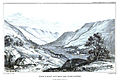 Plate 16.
 -
 Plate 17.
 -
 Plate 18.
 -
 Plate 19.
 -
 Plate 20.
 -
 Plate 21.
 -
 Plate 22.


- ↑ I think it right to remark that every precaution was taken in ascertaining both the levels and the elevations which will be referred to in the arguments hereafter to be used. Those which could not be accurately determined, on account of the nature and extent of the ground requiring a survey, have been estimated by such approximations as were attainable, and these are distinguished wherever they occur. However imperfect, they are no where so lax as to affect the arguments, even if the errors were much greater than any which could have occurred, as no undue stress as any where laid on hypothetical assumptions. The levels of the lines were observed by a spirit level, and the vertical distances between them were measured by the same instrument. One barometer of Ramsden's construction was applied for the measurement of the elevations; and such differences between any two altitudes as were required, were ascertained by observations repeated at very short intervals. For determining the absolute altitudes above the level of the sea, the barometric observations were compared with a register kept purposely for these experiments by Lord Gray at Kinfauns Castle, those observations, with the required corrections, being made at the same hours with instruments of similar construction. To remove still more any chance of error, the principal altitudes were deduced from a medium of nine observations taken on four different days, the greatest variations between the extremes not exceeding one twelfth of the whole. The altitude of the great Caledonian valley is known from the measurements belonging to the canal.
Notwithstanding all this care however, I can only consider these altitudes as approximations, since I am convinced from a careful comparison of barometric registers that this instrument cannot be relied on when used in this manner, as I have attempted to show in late communication to this Society.
The principal map does not pretend to be an accurate survey. The defective nature of all the maps of Scotland hitherto constructed, as well as the smallness of their scales, prevented me from making any use of them for this purpose; but as the description would have been unintelligible without some sketch of the ground, I have given one which must however be considered merely in the light of a military reconnaissance. The sections do not pretend to be real. The transverse ones are, like the map, delineated without attention to their true proportions, and are merely intended to mark the important variations of the form of the bottom of the valley, and more particularly the points in which the lines and the terraces coincide. The curved longitudinal sections are equally artificial, but they assist the imagination in pursuing the wide connections of Glen Roy with the sea. The profiles of the lines are deduced from actual measurement by the spirit level.
Of the accompanying views I need only say that they are intended to elucidate several parts of the description, and to convey a slight notion of the nature of the appearances in question. The purposes of the two other maps in showing the connections of Glen Roy with the neighbouring and with the more distant country will be obvious.
- ↑ The map, Pl. 20, is copied from Arrowsmith's work, and contains various lines supposed to be seen in the adjoining vallies. I have retained them in all the places which I had no opportunity of examining, without intending to be responsible for their existence. Where they did not agree with my own observations I have without scruple omitted or altered them.
- ↑ Plate 18.
- ↑ Plate 18, Profiles No. 3, 5.
- ↑ Sect. L, Plate 21.
- ↑ Plate 14, 15.
- ↑ Plate 18.
- ↑ Plate 18, Profile No. 8.
- ↑ Plate 18.
- ↑ Plate 18.
- ↑ Sect. K, Plate 21.—Plate 18.
- ↑ Plates 14, 15.
- ↑ Pl. 18.
- ↑ As a convenient reference to the render, I have however thought proper to tabulate in one view all the measurements relating to this subject which are in any way interesting; many of them being objects of general curiosity, even when not particularly connected with this subject year.
feet Upper line of Glen Roy, above the Western sea at Loch Eil 1262 Ditto above the German sea 1266 Lowest line of ditto, above the Western sea 976 Upper line of ditto, above the land at Loch Oich 1180 Lowest line of ditto, above the same 886 Upper line above the second of Glen Roy 82 Second line above the lowest ditto 212 Upper line of Glen Roy, above the junction of the Roy and Spean 927 Lowest ditto, above the same place 633 Upper line of ditto, above the bottom of the Glen where the Roy enters it 283 Height of the bottom at that place above the lowest line. 11 Upper line of Glen Roy above Loch Spey 63 The bottom of Glen Roy at its upper end, above its bottom at the junction of the Roy and Spean; or its declivity 644 Height from the junction of the Roy and Spean to the sea 343 Observed upper lane of Glen Gloy, above the Western sea. 1274 Difference of level between ditto and the upper line of Glen Roy 12 Height of Loch Spey above Garvamore 294 Ditto above the German sea 1203 Height of Garvamore, or fall of the Spey hence to the sea 909 Depression of the eastern barrier of Loch Laggan, below the upper lane of Glen Roy 432 Whatever doubts we may have respecting the general value of the method by which the elevation of the upper lane of Glen Roy was ascertained, I must here remark that this principal measurement receives confirmation, to a certain extent at least, by comparison with the height of that land which is the common division of the Truim and the Garry. This point has been found by levelling to be 1460 feet, and it appears probable from comparing the course of the former river and that of the Spey to their common junction, that the source of the Spey cannot be materially different in elevation; a circumstance confirmed by the barometric observations. The other measurements in the table scarcely admit of any material errors.
- ↑ Pl. 16.
- ↑ P1. 21. Sect. F.
- ↑ Pl. 21. Sect. E.
- ↑ Vide Horizontal Section, E.F. Pl. 21.
- ↑ See Plates 19, 20.
- ↑ Vide Profiles Pl. 18.
- ↑ Prof. 1, 5.
- ↑ Prof. 8.
- ↑ Prof. 7.
- ↑ Prof. 6.
- ↑ Pl. 19.
- ↑ Plate 19.
- ↑ Plate 19.
- ↑ Plate 18.
- ↑ Pl. 18. Pl. 21. Section M. N.
- ↑ Vide Plates 18, 21, 22.
- ↑ Vide the tabulated admeasurements (note to page 326) where it will be seen that the bottom of the valley at its upper part is 11 feet above the lowest line.─Vide also, Section (6), Pl. (22).
- ↑ Plate 15. Plate 21. Sect. L.
- ↑ Pl. 14, 15. Pl. 21. Sect. K, L.
- ↑ P1. 21, Section L. and Pl. 15
- ↑ Vide Pl. 19.
- ↑ The coloured map will explain both this circumstance and the various directions in which water raised to the upper line of Glen Roy would now flow to the sea. The necessary distinction will be easily made by attending to the description.